Search This Blog

Sunday, October 27, 2024

https://youtu.be/pOdMipcgCsU

This document promotes the use of artificial intelligence (AI), machine learning (ML), and traditional statistics in geochemical data analysis, arguing that these technologies can revolutionize the field by unlocking hidden patterns and enhancing predictive capabilities. The author contends that integrating AI and ML can improve data analysis efficiency, automate tasks, and generate robust predictive models, ultimately leading to groundbreaking discoveries and innovations in understanding Earth's composition and processes. P. Geo. Ricardo A Valls, M. Sc. and Geo Gadfly Valls Geoconsultant ORCID ID- https://orcid.org/0000-0002-5421-0914 Scopus Author ID: 7003369619/35335510700 ResearcherID: S-6604-2018 If you like this content, please "buy me a coffee" https://www.buymeacoffee.com/goldendroplets

https://youtu.be/C3O9QaOLpEA

This video explores the reasons behind gold's significantly higher value compared to copper, despite copper's greater practical utility. The analysis delves into economic factors such as rarity and monetary roles, industrial applications, investment demand, and cultural significance. While copper is crucial for modern technology and infrastructure, gold's scarcity, historical importance as a store of value, and cultural prestige contribute to its higher price. The video critically examines whether this value disparity is justified in terms of utility and considers a hypothetical scenario where metals are valued solely on their practical applications. It concludes that while copper may be more useful in everyday life, gold's value is deeply rooted in complex economic and cultural factors. The piece also touches on potential future shifts in relative values as technology and societal priorities evolve. P. Geo. Ricardo A Valls, M. Sc. and Geo Gadfly Valls Geoconsultant ORCID ID- https://orcid.org/0000-0002-5421-0914 Scopus Author ID: 7003369619/35335510700 ResearcherID: S-6604-2018 If you like this content, please "buy me a coffee" https://www.buymeacoffee.com/goldendroplets

Saturday, October 26, 2024

https://youtu.be/tedEmjgsrpU

P. Geo. Ricardo A Valls, M. Sc. and Geo Gadfly Valls Geoconsultant ORCID ID- https://orcid.org/0000-0002-5421-0914 Scopus Author ID: 7003369619/35335510700 ResearcherID: S-6604-2018 If you like this content, please "buy me a coffee" https://www.buymeacoffee.com/goldendroplets

https://youtu.be/GaX-g32AT10

P. Geo. Ricardo A Valls, M. Sc. and Geo Gadfly Valls Geoconsultant ORCID ID- https://orcid.org/0000-0002-5421-0914 Scopus Author ID: 7003369619/35335510700 ResearcherID: S-6604-2018 If you like this content, please "buy me a coffee" https://www.buymeacoffee.com/goldendroplets

https://youtu.be/MHZlSCx2AH0

Emeralds are rarer than diamonds in terms of known deposits, with only 49 emerald deposits compared to about 1,000 diamond-containing rock formations. However, the diamond industry is more established, producing 100-150 million carats annually, while emerald production is estimated at 7-10 tons per year from major producing countries. Both gemstones require unique geological circumstances for formation. Diamonds form deep in the Earth's mantle and are brought to the surface through rare kimberlite eruptions, while emeralds form in more complex geological formations where beryllium-rich igneous rocks interact with chromium and vanadium-rich sedimentary rocks. The formation processes of these gemstones differ significantly. Diamonds crystallize as carbon under high pressure and temperature in the mantle, requiring volcanic eruptions to bring them to minable depths. Emeralds, on the other hand, form when beryllium-rich environments meet chromium and vanadium-rich areas, often in collisional zones like mountains. While both gemstones have special formation conditions, emeralds are considered rarer in terms of accessibility to humans due to their more complex geological requirements and smaller-scale mining operations. P. Geo. Ricardo A Valls, M. Sc. and Geo Gadfly Valls Geoconsultant ORCID ID- https://orcid.org/0000-0002-5421-0914 Scopus Author ID: 7003369619/35335510700 ResearcherID: S-6604-2018 If you like this content, please "buy me a coffee" https://www.buymeacoffee.com/goldendroplets

Friday, October 25, 2024

¿Deberíamos de darle las gracias? El impacto de un meteorito que ayudó a la vida a prosperar hace 3.000 millones de años

Un reciente estudio ha revelado que un impacto meteorítico masivo, ocurrido hace 3.260 millones de años, no solo devastó el medio ambiente de la Tierra, sino que también lo enriqueció, permitiendo que las bacterias prosperaran. Este hallazgo ofrece nuevas perspectivas sobre la vida primitiva en nuestro planeta y plantea la pregunta: ¿deberíamos de darle las gracias a estos eventos catastróficos por fomentar la vida? A continuación, exploraremos cómo estos impactos masivos tuvieron un lado positivo para la vida.

Tabla de contenidos

🌍 La historia de los impactos meteoríticos

Desde hace miles de millones de años, los meteoritos han bombardeado regularmente la Tierra. Uno de estos impactos, el meteorito S2, fue aproximadamente 200 veces más grande que el que causó la extinción de los dinosaurios. Este evento cataclísmico no solo alteró el entorno terrestre, sino que también desempeñó un papel crucial en el desarrollo de la vida primitiva.

Impacto meteorítico en la Tierra

🧪 La investigación de la Dra. Nadja Drabon

La Dra. Nadja Drabon, geóloga de la Tierra primitiva y profesora adjunta en Harvard, ha estado investigando estos antiguos impactos. Su trabajo se centra en entender cómo eran las condiciones de la Tierra durante los eones de bombardeos meteoríticos, cuando solo existían bacterias unicelulares y arqueas. A través de un estudio publicado en la Proceedings of the National Academy of Sciences, ella y su equipo han comenzado a desentrañar cómo un impacto de tal magnitud pudo haber influido en la evolución de la vida.

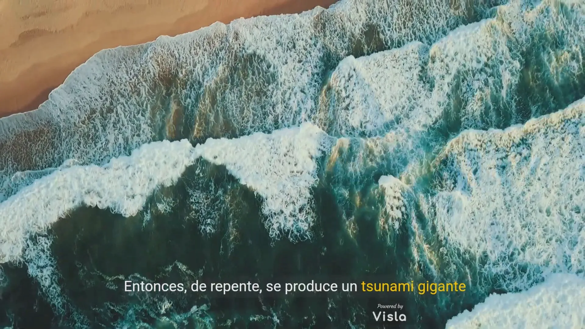
🌊 El impacto S2 y sus consecuencias

El impacto del meteorito S2, que se estima era del tamaño de cuatro montañas Everest, provocó un tsunami gigante que mezcló las aguas oceánicas y arrastró escombros hacia las zonas costeras. El calor generado por el impacto provocó la ebullición de la capa superior del océano y creó una densa nube de polvo que cubrió el planeta, paralizando la actividad fotosintética.

Simulación de tsunami causado por el impacto

🌱 Resiliencia de la vida bacteriana

A pesar de la devastación, las bacterias demostraron ser resistentes. Según el análisis del equipo de Drabon, la vida bacteriana se recuperó rápidamente tras el impacto, lo que desencadenó un aumento en las poblaciones de organismos unicelulares que se alimentan de fósforo y hierro. Este cambio hacia bacterias que metabolizan hierro es fundamental para entender la vida primitiva en la Tierra.

🔍 Un vistazo al pasado geológico

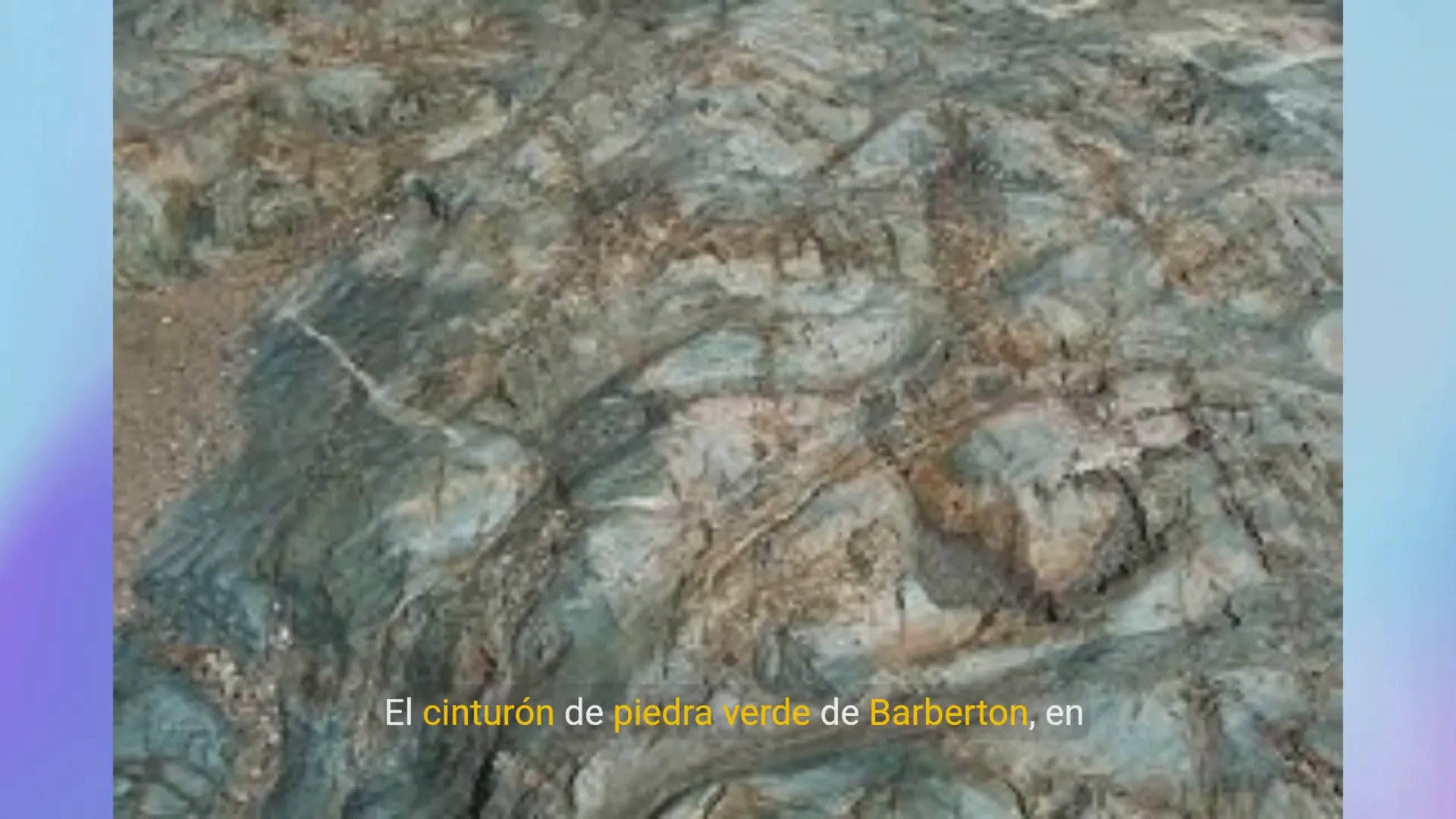
El Cinturón de Piedras Verdes de Barberton en Sudáfrica contiene pruebas de al menos ocho impactos meteoríticos, incluido el S2. Drabon y su equipo planean continuar su estudio en esta zona para profundizar en la historia de la Tierra y su relación con los meteoritos. Las firmas químicas ocultas en las capas de roca ayudan a reconstruir la evidencia de tsunamis y otros eventos cataclísmicos.

Cinturón de Piedras Verdes de Barberton

❓ Preguntas frecuentes

¿Qué es el meteorito S2?

El meteorito S2 es un impacto que ocurrió hace 3.260 millones de años, considerado uno de los más grandes en la historia de la Tierra, que tuvo un papel importante en el enriquecimiento del medio ambiente y la prosperidad de la vida primitiva.

¿Cómo afectó el impacto a la vida en la Tierra?

El impacto provocó un tsunami que mezcló los océanos y trajo nutrientes esenciales como el fósforo y el hierro, permitiendo que las bacterias prosperaran en un entorno que había sido devastado.

¿Por qué los impactos meteoríticos pueden ser beneficiosos?

A pesar de su naturaleza destructiva, los impactos pueden enriquecer el medio ambiente con nutrientes que son esenciales para la vida, facilitando la recuperación y el crecimiento de organismos unicelulares.

☕ Apoyo a la investigación

Si te interesa este tipo de investigaciones y quieres apoyar los esfuerzos de los científicos en cerrar la brecha entre la industria y la academia, considera visitar Golden Droplets para contribuir con un café.

En conclusión, el impacto del meteorito S2, aunque devastador, también proporcionó condiciones que permitieron la prosperidad de la vida bacteriana en la Tierra primitiva. Estos eventos catastróficos, que a menudo son vistos como desastres, también pueden ser considerados como catalizadores de la vida. ¿Deberíamos de darle las gracias? La respuesta parece ser un rotundo sí.

P. Geo. Ricardo A Valls, M. Sc.

Valls Geoconsultant

ORCID ID- https://orcid.org/0000-0002-5421-0914

Scopus Author ID: 7003369619/35335510700

ResearcherID: S-6604-2018

If you like this content, please "buy me a coffee" https://www.buymeacoffee.com/goldendroplets

#planetearth #geology #mining #exploration #education #earthscience #geologia #earthscienceteacher #cienciasnaturales #cienciasgeologicas #geochemistry #geochemistrybooks #geoquimica #trainingcourses #teachingonline #vallsgeoconsultant #vallsvg #technotectonics #goldendroplets #geovoices

Valls Geoconsultant YouTube channel

More than 1000 videos about Geology

Click me

https://youtu.be/TJj8FmTLcgM

Hace unos 3.260 millones de años, un meteorito colosal impactó contra la Tierra, alterando para siempre su entorno. Este impacto, 200 veces mayor que el que provocó la extinción de los dinosaurios, desencadenó un tsunami y calentó los océanos, alterando el tranquilo entorno de la Tierra primitiva. Sin embargo, a pesar de la devastación, el acontecimiento tuvo un lado positivo sorprendente. El análisis de rocas del Cinturón de Piedras Verdes de Barberton, en Sudáfrica, sugiere que el impacto masivo aportó elementos cruciales como el hierro y el fósforo, creando condiciones favorables para que prosperara la vida bacteriana. Estos nutrientes, posiblemente traídos por el meteorito y removidos desde las profundidades oceánicas, ayudaron a las bacterias primitivas a recuperarse y florecer tras el impacto. El estudio de la Dra. Nadja Drabon subraya que, aunque a menudo asociamos los impactos de meteoritos con la destrucción, también podrían haber desempeñado un papel fundamental en la nutrición de la vida primitiva en la Tierra. La investigación sugiere que tales impactos enriquecieron el medio ambiente, estimulando el crecimiento microbiano y creando nuevas oportunidades para la evolución de la vida. Los hallazgos revelan cómo los acontecimientos catastróficos, como el impacto del meteorito S2, moldearon la historia biológica y geológica de la Tierra, ofreciendo una visión de la relación entre la evolución planetaria y la resistencia de la vida. P. Geo. Ricardo A Valls, M. Sc. and Geo Gadfly Valls Geoconsultant ORCID ID- https://orcid.org/0000-0002-5421-0914 Scopus Author ID: 7003369619/35335510700 ResearcherID: S-6604-2018 If you like this content, please "buy me a coffee" https://www.buymeacoffee.com/goldendroplets

https://youtu.be/uUvflvMiNRM

Around 3.26 billion years ago, a colossal meteorite struck Earth, forever altering its environment. This impact, 200 times larger than the one that caused the extinction of the dinosaurs, triggered a tsunami and heated the oceans, disrupting early Earth's calm environment. However, despite the devastation, the event had a surprising upside. The analysis of rocks from the Barberton Greenstone Belt in South Africa suggests that the massive impact provided crucial elements like iron and phosphorus, creating favorable conditions for bacterial life to thrive. These nutrients, possibly brought by the meteorite and stirred from the ocean depths, helped primitive bacteria recover and flourish in the aftermath. Dr. Nadja Drabon’s study emphasizes that while we often associate meteorite impacts with destruction, they might have also played a critical role in nurturing early life on Earth. The research suggests that such impacts enriched the environment, spurring microbial growth and creating new opportunities for life's evolution. The findings reveal how catastrophic events, like the S2 meteorite impact, shaped Earth's biological and geological history, offering insights into the relationship between planetary evolution and life's resilience. P. Geo. Ricardo A Valls, M. Sc. and Geo Gadfly Valls Geoconsultant ORCID ID- https://orcid.org/0000-0002-5421-0914 Scopus Author ID: 7003369619/35335510700 ResearcherID: S-6604-2018 If you like this content, please "buy me a coffee" https://www.buymeacoffee.com/goldendroplets

https://youtu.be/k3DQFbSNNxY

The source documents provide a comprehensive account of the Bre-X mining scandal, a major fraud in the 1990s that involved the discovery of a purported gold deposit in Indonesia. The first source examines the scandal's historical context, detailing how Bre-X, a Calgary-based gold exploration company, rose to prominence based on exaggerated gold estimates. The second source focuses on the dramatic collapse of the scheme, emphasizing the devastating consequences for investors and the resulting regulatory changes in the mining industry. The third source examines the specific regulations that emerged in Canada and Australia to address the issues raised by the scandal. P. Geo. Ricardo A Valls, M. Sc. and Geo Gadfly Valls Geoconsultant ORCID ID- https://orcid.org/0000-0002-5421-0914 Scopus Author ID: 7003369619/35335510700 ResearcherID: S-6604-2018 If you like this content, please "buy me a coffee" https://www.buymeacoffee.com/goldendroplets

Thursday, October 24, 2024

https://youtu.be/6AH8c0X5sxo

El 24 de octubre se celebra el Día del Trabajador Geólogo en Cuba para reconocer el esfuerzo y la labor de quienes trabajan en la prospección, perforación y explotación de yacimientos minerales. Esta fecha conmemora un evento histórico ocurrido en 1960, cuando las empresas geólogo-mineras en Cuba fueron nacionalizadas, pasando de manos de compañías extranjeras a ser propiedad del nuevo gobierno. P. Geo. Ricardo A Valls, M. Sc. and Geo Gadfly Valls Geoconsultant ORCID ID- https://orcid.org/0000-0002-5421-0914 Scopus Author ID: 7003369619/35335510700 ResearcherID: S-6604-2018 If you like this content, please "buy me a coffee" https://www.buymeacoffee.com/goldendroplets

https://youtu.be/4d--FgZIRuI

The source delves into the Bre-X mining scandal, a case of widespread fraud involving the deliberate manipulation of gold core samples taken from a site in Borneo. The source explains how geologist Michael de Guzman "salted" the samples with external gold to inflate the apparent gold content, then falsified the existence of second core samples to prevent independent verification of his claims. The source further examines the role of various entities involved, including assay labs, investment firms, and engineering companies, highlighting instances where a lack of professional skepticism and independent oversight allowed the fraud to persist for years. P. Geo. Ricardo A Valls, M. Sc. and Geo Gadfly Valls Geoconsultant ORCID ID- https://orcid.org/0000-0002-5421-0914 Scopus Author ID: 7003369619/35335510700 ResearcherID: S-6604-2018 If you like this content, please "buy me a coffee" https://www.buymeacoffee.com/goldendroplets

Wednesday, October 23, 2024

https://youtu.be/BmGhZzMfU44

The source tells the story of the Bre-X mining scandal, a fraudulent scheme that involved a junior mining company called Bre-X Minerals. The scandal, which took place in Indonesia during the 1990s, involved the company's deliberate misrepresentation of the gold content at a mining site called Busang. The source details how the company, led by David Walsh, used a geologist named Michael de Guzman to falsify the gold assays, which resulted in a significant overvaluation of the company and a surge in its stock price. The source examines the contributing factors to the fraud, including a lack of professional skepticism, a reliance on de Guzman's word, and the company's failure to conduct independent audits. The scandal ultimately resulted in the collapse of Bre-X, the loss of billions of dollars for investors, and a major shift in the mining industry towards stricter regulations and improved due diligence practices. P. Geo. Ricardo A Valls, M. Sc. and Geo Gadfly Valls Geoconsultant ORCID ID- https://orcid.org/0000-0002-5421-0914 Scopus Author ID: 7003369619/35335510700 ResearcherID: S-6604-2018 If you like this content, please "buy me a coffee" https://www.buymeacoffee.com/goldendroplets

Tuesday, October 22, 2024

https://youtu.be/B9j9QgFarjY

भूविज्ञानी मिट्टी का विश्लेषण करने के लिए उन्नत तकनीकों का उपयोग करते हैं, जिससे सतह के नीचे छिपे कटाव और संभावित खनिज भंडार के बारे में महत्वपूर्ण जानकारी सामने आती है। प्रक्रिया एक संरचित मिट्टी नमूना ग्रिड के साथ शुरू होती है, जो अध्ययन क्षेत्र में सटीक डेटा संग्रह सुनिश्चित करती है। चांदी, जस्ता, निकल और कोबाल्ट जैसे विशिष्ट तत्वों की जांच करके, भूवैज्ञानिक कटाव के स्तर की गणना कर सकते हैं और परिदृश्य में ऐतिहासिक परिवर्तनों को उजागर कर सकते हैं। इसमें विभिन्न मिट्टी के घटकों के बीच संबंधों को समझने के लिए केंद्रित लॉग अनुपात परिवर्तन जैसे तरीकों का उपयोग करना शामिल है। सॉफ़्टवेयर सर्फर इस डेटा को विज़ुअलाइज़ करने, जटिल जानकारी को सुलभ मानचित्रों में बदलने में महत्वपूर्ण भूमिका निभाता है जो मौलिक सांद्रता और क्षरण पैटर्न को उजागर करता है। डेटा में विसंगतियाँ छिपे हुए खनिज संसाधनों या पर्यावरणीय चिंताओं का संकेत दे सकती हैं, जो उन्हें आगे की जांच के लिए मूल्यवान बनाती हैं। कुल मिलाकर, सावधानीपूर्वक नमूनाकरण, डेटा विश्लेषण और विज़ुअलाइज़ेशन का यह संयोजन न केवल संसाधन खोज में सहायता करता है बल्कि पर्यावरण संरक्षण और प्रबंधन प्रयासों में भी योगदान देता है। P. Geo. Ricardo A Valls, M. Sc. and Geo Gadfly Valls Geoconsultant ORCID ID- https://orcid.org/0000-0002-5421-0914 Scopus Author ID: 7003369619/35335510700 ResearcherID: S-6604-2018 If you like this content, please "buy me a coffee" https://www.buymeacoffee.com/goldendroplets

https://youtu.be/I_4LTA57vjg

Geologists utilize advanced techniques to analyze soil, revealing crucial information about erosion and potential mineral deposits hidden beneath the surface. The process begins with a structured soil sampling grid, ensuring accurate data collection across the study area. By examining specific elements like silver, zinc, nickel, and cobalt, geologists can calculate erosional levels and uncover the historical changes in the landscape. This involves using methods such as centered log ratio transformations to understand the relationships between different soil components. The software Surfer plays a vital role in visualizing this data, transforming complex information into accessible maps that highlight elemental concentrations and erosional patterns. Anomalies in the data can indicate hidden mineral resources or environmental concerns, making them valuable for further investigation. Overall, this combination of meticulous sampling, data analysis, and visualization not only aids in resource discovery but also contributes to environmental protection and management efforts. P. Geo. Ricardo A Valls, M. Sc. and Geo Gadfly Valls Geoconsultant ORCID ID- https://orcid.org/0000-0002-5421-0914 Scopus Author ID: 7003369619/35335510700 ResearcherID: S-6604-2018 If you like this content, please "buy me a coffee" https://www.buymeacoffee.com/goldendroplets

https://youtu.be/AjyvvaIuM_A

Геологи используют передовые методы для анализа почвы, выявляя важнейшую информацию об эрозии и потенциальных залежах полезных ископаемых, скрытых под поверхностью. Процесс начинается со структурированной сетки отбора проб почвы, обеспечивающей точный сбор данных на всей исследуемой территории. Исследуя специфические элементы, такие как серебро, цинк, никель и кобальт, геологи могут рассчитать уровни эрозии и раскрыть исторические изменения ландшафта. Для этого используются такие методы, как центрированные преобразования log ratio, чтобы понять взаимосвязь между различными компонентами почвы. Программное обеспечение Surfer играет важную роль в визуализации этих данных, преобразуя сложную информацию в доступные карты, которые подчеркивают концентрацию элементов и эрозионные закономерности. Аномалии в данных могут указывать на скрытые минеральные ресурсы или экологические проблемы, что делает их ценными для дальнейшего исследования. В общем, такое сочетание тщательного отбора проб, анализа данных и визуализации не только помогает в обнаружении ресурсов, но и способствует усилиям по защите и рациональному использованию окружающей среды. P. Geo. Ricardo A Valls, M. Sc. and Geo Gadfly Valls Geoconsultant ORCID ID- https://orcid.org/0000-0002-5421-0914 Scopus Author ID: 7003369619/35335510700 ResearcherID: S-6604-2018 If you like this content, please "buy me a coffee" https://www.buymeacoffee.com/goldendroplets

Monday, October 21, 2024

https://youtu.be/9dSPows1qAY

Pueden leer el ebook en español acá- https://tinyurl.com/3aupv879 Listen to "Espeloemineralogy" by Geo-News Radio. https://podcasters.spotify.com/pod/show/vg1958/episodes/Espeloemineralogy-e2pv1lq P. Geo. Ricardo A Valls, M. Sc. and Geo Gadfly Valls Geoconsultant ORCID ID- https://orcid.org/0000-0002-5421-0914 Scopus Author ID: 7003369619/35335510700 ResearcherID: S-6604-2018 If you like this content, please "buy me a coffee" https://www.buymeacoffee.com/goldendroplets

https://youtu.be/cXL-oF3LOxA

यह अध्ययन सल्फाइड खनिजों की रासायनिक संरचना की जांच करता है, विशेष रूप से च्लोकोपाइराइट, स्फालेराइट और पाइराइट, जो तीन प्रमुख स्ट्रैटिफॉर्म तलछट-होस्टेड तांबे और कोबाल्ट जमा में पाए जाते हैं: पोलिश कुफ़र्सचिफ़र, सेंट्रल अफ़्रीकी कॉपरबेल्ट, और नामीबियाई डोलोस्टोन अयस्क संरचना। लेज़र एब्लेशन इंडक्टिवली कपल्ड प्लाज़्मा मास स्पेक्ट्रोमेट्री (एलए-आईसीपी-एमएस) का उपयोग करके, शोधकर्ताओं ने सल्फाइड में विशिष्ट ट्रेस तत्व हस्ताक्षर की पहचान की, जिससे उन्हें जमाओं के बीच अंतर करने की अनुमति मिली। अध्ययन से यह भी पता चला कि सल्फाइड रसायन मेजबान बेसिन के भूविज्ञान, अंतर्निहित तहखाने की चट्टानों और खनिजकरण के विभिन्न चरणों से प्रभावित होता है। ये निष्कर्ष इन जमाओं की उत्पत्ति और विकास को समझने में ट्रेस तत्व भू-रसायन विज्ञान के महत्व पर प्रकाश डालते हैं और सुझाव देते हैं कि मशीन सीखने की तकनीक भविष्य में समान खनिज जिलों को वर्गीकृत और विश्लेषण करने के लिए उपयोगी हो सकती है। P. Geo. Ricardo A Valls, M. Sc. and Geo Gadfly Valls Geoconsultant ORCID ID- https://orcid.org/0000-0002-5421-0914 Scopus Author ID: 7003369619/35335510700 ResearcherID: S-6604-2018 If you like this content, please "buy me a coffee" https://www.buymeacoffee.com/goldendroplets

https://youtu.be/T9wHHwAXnJY

Este estudio examina la composición química de los minerales de sulfuro, concretamente calcopirita, esfalerita y pirita, hallados en tres importantes yacimientos estratiformes de cobre y cobalto alojados en sedimentos: el Kupferschiefer polaco, el Cinturón de Cobre centroafricano y la Formación Mineral Dolostone de Namibia. Mediante espectrometría de masas con plasma de acoplamiento inductivo por ablación láser (LA-ICP-MS), los investigadores identificaron distintas firmas de oligoelementos en los sulfuros, lo que les permitió diferenciar los yacimientos. El estudio también reveló que la química de los sulfuros está influida por la geología de la cuenca anfitriona, las rocas del basamento subyacente y las distintas fases de mineralización. Estos hallazgos ponen de relieve la importancia de la geoquímica de los oligoelementos para comprender los orígenes y la evolución de estos yacimientos y sugieren que las técnicas de aprendizaje automático pueden ser útiles para clasificar y analizar distritos minerales similares en el futuro. P. Geo. Ricardo A Valls, M. Sc. and Geo Gadfly Valls Geoconsultant ORCID ID- https://orcid.org/0000-0002-5421-0914 Scopus Author ID: 7003369619/35335510700 ResearcherID: S-6604-2018 If you like this content, please "buy me a coffee" https://www.buymeacoffee.com/goldendroplets

https://youtu.be/Z_H0761swZY

В этом исследовании рассматривается химический состав сульфидных минералов, в частности халькопирита, сфалерита и пирита, обнаруженных в трех крупных стратиформных осадочных месторождениях меди и кобальта: польском Купфершифер, центральноафриканском Коппербелт и намибийской рудной формации Долостоун. С помощью масс-спектрометрии с индуктивно связанной плазмой (LA-ICP-MS), основанной на лазерной абляции, исследователи выявили в сульфидах различные подписи микроэлементов, что позволило им провести различие между месторождениями. Исследование также показало, что на химию сульфидов влияют геология вмещающего бассейна, подстилающие породы фундамента и различные стадии минерализации. Эти результаты подчеркивают важность геохимии микроэлементов для понимания происхождения и эволюции этих месторождений и предполагают, что методы машинного обучения могут быть полезны для классификации и анализа подобных минеральных районов в будущем. P. Geo. Ricardo A Valls, M. Sc. and Geo Gadfly Valls Geoconsultant ORCID ID- https://orcid.org/0000-0002-5421-0914 Scopus Author ID: 7003369619/35335510700 ResearcherID: S-6604-2018 If you like this content, please "buy me a coffee" https://www.buymeacoffee.com/goldendroplets

Sunday, October 20, 2024

https://youtu.be/5DUlCemSBso

🌍 Master the art of geochemical data representation! Check out our blog for insights on using Surfer and MapViewer to visualize mineral anomalies effectively. https://www.videoToBlog.ai/share/eZ2v6ThsZzb0dIDjtZlv This YouTube video, "Golden Droplets Episode 26," from the channel "Ricardo Valls," is a tutorial on how to create geochemical maps using Surfer and MapViewer software. The video focuses on using data from stream sediments and heavy mineral concentrates, which are naturally moved downstream from their source, to identify the origin of mineralization. It covers various techniques for visualizing data, including bar graphs, scatter plots, and pie charts. The tutorial concludes by demonstrating how to delineate watersheds, essential for understanding the potential movement of mineralization within a landscape. The video emphasizes that the location of a mineral anomaly in a stream sediment or heavy mineral concentrate sample does not represent the source of the mineralization and that interpreting the data requires tracing the flow of water upstream. P. Geo. Ricardo A Valls, M. Sc. and Geo Gadfly Valls Geoconsultant ORCID ID- https://orcid.org/0000-0002-5421-0914 Scopus Author ID: 7003369619/35335510700 ResearcherID: S-6604-2018 If you like this content, please "buy me a coffee" https://www.buymeacoffee.com/goldendroplets

Saturday, October 19, 2024

https://youtu.be/bPrI3IQA_vU

P. Geo. Ricardo A Valls, M. Sc. and Geo Gadfly Valls Geoconsultant ORCID ID- https://orcid.org/0000-0002-5421-0914 Scopus Author ID: 7003369619/35335510700 ResearcherID: S-6604-2018 If you like this content, please "buy me a coffee" https://www.buymeacoffee.com/goldendroplets

https://youtu.be/IPvQcm4Bd9o

P. Geo. Ricardo A Valls, M. Sc. and Geo Gadfly Valls Geoconsultant ORCID ID- https://orcid.org/0000-0002-5421-0914 Scopus Author ID: 7003369619/35335510700 ResearcherID: S-6604-2018 If you like this content, please "buy me a coffee" https://www.buymeacoffee.com/goldendroplets

https://youtu.be/SLxM3t6AmLA

अयस्क भूविज्ञान समीक्षा का यह शोध लेख उत्तरी चीन क्रेटन में स्थित जियापिगौ सोने के भंडार की उत्पत्ति का पता लगाता है। पाइराइट की संरचना और बनावट का अध्ययन करके, लेखकों ने खनिज द्रव्यों और सोने के संवर्धन में शामिल प्रक्रियाओं की जांच की। उन्हें दो अलग-अलग पाइराइट प्रकारों के प्रमाण मिले, जिनमें से प्रत्येक में एक विशिष्ट ट्रेस तत्व हस्ताक्षर की विशेषता थी, जिससे पता चला कि सोने का खनिजकरण कई चरणों में हुआ। द्रव समावेशन विश्लेषण से पता चला कि अयस्क बनाने वाले तरल पदार्थ कम से मध्यम लवणता, कार्बोनिक-जलीय संरचना वाले थे, और संभवतः उबलते हुए थे। सल्फर आइसोटोप डेटा ने इस विचार का समर्थन किया कि खनिज तरल पदार्थ एक क्रस्टल स्रोत से प्राप्त हुए थे। यह अध्ययन जियापिगौ सोने के भंडार की विस्तृत समझ प्रदान करता है, जिसमें द्रव-चट्टान संपर्क के महत्व और सोने की वर्षा में उबलने की भूमिका पर प्रकाश डाला गया है। P. Geo. Ricardo A Valls, M. Sc. and Geo Gadfly Valls Geoconsultant ORCID ID- https://orcid.org/0000-0002-5421-0914 Scopus Author ID: 7003369619/35335510700 ResearcherID: S-6604-2018 If you like this content, please "buy me a coffee" https://www.buymeacoffee.com/goldendroplets

https://youtu.be/IEXuR3cAkPc

В этой научной статье из журнала Ore Geology Reviews рассматривается происхождение золотого месторождения Цзяпигоу, расположенного в Северо-Китайском кратоне. Изучив состав и текстуру пирита, авторы исследовали минерализующие флюиды и процессы, участвующие в обогащении золота. Они обнаружили доказательства существования двух различных типов пирита, каждый из которых характеризовался специфической подписью микроэлементов, что позволило предположить, что минерализация золота происходила в несколько этапов. Анализ флюидных включений показал, что рудообразующие флюиды были низкой или умеренной солености, углекислотно-водного состава и, вероятно, подвергались кипению. Данные по изотопам серы еще больше подтвердили идею о том, что минерализующие флюиды были получены из корового источника. Это исследование дает детальное понимание золотого месторождения Цзяпигоу, подчеркивая важность взаимодействия флюидов с горными породами и роль кипения в осаждении золота. P. Geo. Ricardo A Valls, M. Sc. and Geo Gadfly Valls Geoconsultant ORCID ID- https://orcid.org/0000-0002-5421-0914 Scopus Author ID: 7003369619/35335510700 ResearcherID: S-6604-2018 If you like this content, please "buy me a coffee" https://www.buymeacoffee.com/goldendroplets

https://youtu.be/fvUjTH_VWvU

This research article from Ore Geology Reviews explores the origin of the Jiapigou gold deposit located in the North China Craton. By studying the composition and texture of pyrite, the authors investigated the mineralizing fluids and the processes involved in gold enrichment. They found evidence for two distinct pyrite types, each characterized by a specific trace element signature, which suggested that gold mineralization occurred in multiple stages. Fluid inclusion analysis revealed that the ore-forming fluids were low to moderate salinity, carbonic-aqueous compositions, and likely underwent boiling. The sulfur isotope data further supported the idea that the mineralizing fluids were derived from a crustal source. This study provides a detailed understanding of the Jiapigou gold deposit, highlighting the importance of fluid-rock interaction and the role of boiling in gold precipitation. P. Geo. Ricardo A Valls, M. Sc. and Geo Gadfly Valls Geoconsultant ORCID ID- https://orcid.org/0000-0002-5421-0914 Scopus Author ID: 7003369619/35335510700 ResearcherID: S-6604-2018 If you like this content, please "buy me a coffee" https://www.buymeacoffee.com/goldendroplets

https://youtu.be/veWVMpAZFZo

Este artículo de investigación de Ore Geology Reviews explora el origen del yacimiento de oro de Jiapigou, situado en el Cratón de China Septentrional. Mediante el estudio de la composición y la textura de la pirita, los autores investigaron los fluidos mineralizadores y los procesos implicados en el enriquecimiento del oro. Encontraron pruebas de dos tipos distintos de pirita, cada uno caracterizado por una firma específica de oligoelementos, lo que sugería que la mineralización del oro se produjo en múltiples etapas. El análisis de la inclusión de fluidos reveló que los fluidos que formaron el mineral tenían una salinidad de baja a moderada, una composición acuosa carbónica y probablemente hirvieron. Los datos de isótopos de azufre apoyaron aún más la idea de que los fluidos mineralizadores procedían de una fuente de la corteza. Este estudio proporciona una comprensión detallada del yacimiento de oro de Jiapigou, destacando la importancia de la interacción fluido-roca y el papel de la ebullición en la precipitación del oro. P. Geo. Ricardo A Valls, M. Sc. and Geo Gadfly Valls Geoconsultant ORCID ID- https://orcid.org/0000-0002-5421-0914 Scopus Author ID: 7003369619/35335510700 ResearcherID: S-6604-2018 If you like this content, please "buy me a coffee" https://www.buymeacoffee.com/goldendroplets

https://youtu.be/wdtfjqZpL8E

जियोएक्सप्रो में हेंक कोम्ब्रिंक के लेख में चर्चा की गई है कि कैसे अन्वेषण भूविज्ञान का क्षेत्र अधिक व्यक्तिपरक, कला-आधारित दृष्टिकोण से अधिक मात्रात्मक, विज्ञान-आधारित अनुशासन में विकसित हुआ है। लेखक तेल उद्योग में अपने शुरुआती करियर को दर्शाता है, जहां अन्वेषण "गुरुओं" के अनुभव और अंतर्ज्ञान पर बहुत अधिक निर्भर करता था जिन्होंने बहुत सारे भूविज्ञान को देखा था। हालांकि, समय के साथ, जटिल भूवैज्ञानिक प्रक्रियाओं को समझने के लिए कंप्यूटर मॉडल और विश्लेषण का उपयोग करते हुए यह क्षेत्र अधिक डेटा-संचालित हो गया है। जबकि इस बदलाव ने अधिक सटीकता और ज्ञान लाया है, लेख का तर्क है कि अन्वेषण भूविज्ञान अभी भी एक कलात्मक तत्व बरकरार रखता है, क्योंकि इसमें अक्सर सीमित और अनिश्चित डेटा के निर्णय और व्याख्या की आवश्यकता होती है। कोम्ब्रिंक इस बात पर जोर देते हैं कि क्षेत्र में सूचित निर्णय लेने के लिए विभिन्न भूवैज्ञानिक संदर्भों का अनुभव और समझ अभी भी आवश्यक है। P. Geo. Ricardo A Valls, M. Sc. and Geo Gadfly Valls Geoconsultant ORCID ID- https://orcid.org/0000-0002-5421-0914 Scopus Author ID: 7003369619/35335510700 ResearcherID: S-6604-2018 If you like this content, please "buy me a coffee" https://www.buymeacoffee.com/goldendroplets

https://youtu.be/WtSgA5xF6z4

Henk Kombrink's article in GeoExpro discusses how the field of exploration geology has evolved from a more subjective, art-based approach to a more quantitative, science-based discipline. The author reflects on his early career in the oil industry, where exploration relied heavily on the experience and intuition of "gurus" who had seen a lot of geology. Over time, however, the field has become more data-driven, using computer models and analysis to understand complex geological processes. While this shift has brought about greater precision and knowledge, the article argues that exploration geology still retains an artistic element, as it requires judgment and interpretation of often limited and uncertain data. Kombrink emphasizes that experience and understanding of different geological contexts are still essential for making informed decisions in the field. P. Geo. Ricardo A Valls, M. Sc. and Geo Gadfly Valls Geoconsultant ORCID ID- https://orcid.org/0000-0002-5421-0914 Scopus Author ID: 7003369619/35335510700 ResearcherID: S-6604-2018 If you like this content, please "buy me a coffee" https://www.buymeacoffee.com/goldendroplets

https://youtu.be/EP-MBt_I-Bw

Статья Хенка Комбринка в GeoExpro рассказывает о том, как область разведочной геологии эволюционировала от более субъективного, основанного на искусстве подхода к более количественной, основанной на науке дисциплине. Автор размышляет о своей ранней карьере в нефтяной промышленности, где геологоразведка во многом полагалась на опыт и интуицию «гуру», повидавших многое в геологии. Однако со временем эта область стала больше ориентироваться на данные, используя компьютерные модели и анализ для понимания сложных геологических процессов. Хотя этот сдвиг привел к большей точности и знаниям, в статье утверждается, что разведочная геология по-прежнему сохраняет художественный элемент, так как требует суждений и интерпретации зачастую ограниченных и неопределенных данных. Комбринк подчеркивает, что опыт и понимание различных геологических контекстов по-прежнему необходимы для принятия обоснованных решений в полевых условиях. P. Geo. Ricardo A Valls, M. Sc. and Geo Gadfly Valls Geoconsultant ORCID ID- https://orcid.org/0000-0002-5421-0914 Scopus Author ID: 7003369619/35335510700 ResearcherID: S-6604-2018 If you like this content, please "buy me a coffee" https://www.buymeacoffee.com/goldendroplets

https://youtu.be/WWf0SB8njzo

El artículo de Henk Kombrink en GeoExpro analiza cómo el campo de la geología de exploración ha evolucionado desde un enfoque más subjetivo, basado en el arte, a una disciplina más cuantitativa, basada en la ciencia. El autor reflexiona sobre los comienzos de su carrera en la industria petrolera, donde la exploración dependía en gran medida de la experiencia y la intuición de «gurús» que habían visto mucha geología. Con el tiempo, sin embargo, el campo se ha ido orientando más hacia los datos, utilizando modelos y análisis informáticos para comprender los complejos procesos geológicos. Aunque este cambio ha aportado mayor precisión y conocimiento, el artículo sostiene que la geología de exploración sigue conservando un elemento artístico, ya que requiere juicio e interpretación de datos a menudo limitados e inciertos. Kombrink subraya que la experiencia y la comprensión de los distintos contextos geológicos siguen siendo esenciales para tomar decisiones informadas sobre el terreno. P. Geo. Ricardo A Valls, M. Sc. and Geo Gadfly Valls Geoconsultant ORCID ID- https://orcid.org/0000-0002-5421-0914 Scopus Author ID: 7003369619/35335510700 ResearcherID: S-6604-2018 If you like this content, please "buy me a coffee" https://www.buymeacoffee.com/goldendroplets

Thursday, October 17, 2024

https://youtu.be/EvBT4I7O6D4

P. Geo. Ricardo A Valls, M. Sc. and Geo Gadfly Valls Geoconsultant ORCID ID- https://orcid.org/0000-0002-5421-0914 Scopus Author ID: 7003369619/35335510700 ResearcherID: S-6604-2018 If you like this content, please "buy me a coffee" https://www.buymeacoffee.com/goldendroplets

https://youtu.be/ewBIaOmhUYc

P. Geo. Ricardo A Valls, M. Sc. and Geo Gadfly Valls Geoconsultant ORCID ID- https://orcid.org/0000-0002-5421-0914 Scopus Author ID: 7003369619/35335510700 ResearcherID: S-6604-2018 If you like this content, please "buy me a coffee" https://www.buymeacoffee.com/goldendroplets

https://youtu.be/SXmv-Inwc-Y

P. Geo. Ricardo A Valls, M. Sc. and Geo Gadfly Valls Geoconsultant ORCID ID- https://orcid.org/0000-0002-5421-0914 Scopus Author ID: 7003369619/35335510700 ResearcherID: S-6604-2018 If you like this content, please "buy me a coffee" https://www.buymeacoffee.com/goldendroplets

https://youtu.be/3IS7_RCqrPU

P. Geo. Ricardo A Valls, M. Sc. and Geo Gadfly Valls Geoconsultant ORCID ID- https://orcid.org/0000-0002-5421-0914 Scopus Author ID: 7003369619/35335510700 ResearcherID: S-6604-2018 If you like this content, please "buy me a coffee" https://www.buymeacoffee.com/goldendroplets

https://youtu.be/emGBkul2Kok

P. Geo. Ricardo A Valls, M. Sc. and Geo Gadfly Valls Geoconsultant ORCID ID- https://orcid.org/0000-0002-5421-0914 Scopus Author ID: 7003369619/35335510700 ResearcherID: S-6604-2018 If you like this content, please "buy me a coffee" https://www.buymeacoffee.com/goldendroplets

https://youtu.be/oupQoupewoA

यह लेख चंद्रमा के "असंतुलित" भूविज्ञान के आसपास लंबे समय से चले आ रहे रहस्य की जांच करता है और इसके निकट की ओर टाइटेनियम की इतनी उच्च सांद्रता कैसे हुई। वैज्ञानिक आम तौर पर इस बात से सहमत हैं कि चंद्रमा अरबों साल पहले एक छोटे ग्रह के पृथ्वी से टकराने के बाद मलबे से बना था। जैसे ही पिघली हुई चट्टान ठंडी और ठोस हुई, इसने चंद्रमा के आवरण और परत का निर्माण किया। हालाँकि, टाइटेनियम और लौह युक्त सघन खनिज, जैसे इल्मेनाइट, सतह के नीचे अधिक गहराई में क्रिस्टलीकृत होते हैं। भारी इल्मेनाइट ने गुरुत्वाकर्षण अस्थिरता पैदा की, जिससे यह चंद्रमा के आंतरिक भाग में डूब गया, मेंटल के साथ मिल गया और टाइटेनियम युक्त लावा प्रवाह के रूप में फिर से सतह पर आ गया। इस प्रक्रिया ने अनिवार्य रूप से चंद्रमा को "अंदर से बाहर" कर दिया। यह लेख इस बारे में विभिन्न सिद्धांतों की पड़ताल करता है कि यह सघन सामग्री कैसे डूबी, कहां गई और कब हुई। शोधकर्ताओं ने डूबती इल्मेनाइट-समृद्ध परत के सिमुलेशन की तुलना नासा के GRAIL मिशन के डेटा से की, जिसने चंद्रमा के गुरुत्वाकर्षण क्षेत्र को मापा। उनके विश्लेषण से परत के नीचे घने पदार्थ के एक नेटवर्क का पता चला, जो कंप्यूटर मॉडल की भविष्यवाणियों के अनुरूप था। इस खोज से पता चलता है कि इल्मेनाइट-समृद्ध परत चंद्रमा के निकट की ओर चली गई और आंतरिक भाग में डूब गई, और अपने पीछे ऐसे अवशेष छोड़ गई जो चंद्रमा के गुरुत्वाकर्षण क्षेत्र में विसंगतियों का कारण बने। वैज्ञानिकों का मानना ​​है कि निकट की ओर बड़े प्रभाव वाले बेसिनों के स्थान के आधार पर यह प्रक्रिया 4.22 अरब साल पहले हुई थी। शोधकर्ताओं ने निष्कर्ष निकाला कि चंद्रमा का "असंतुलित" भूविज्ञान, इसकी पतली परत, कम ऊंचाई और निकट की ओर टाइटेनियम की प्रचुरता के साथ, संभवतः इस मेंटल पलटने से जुड़ा हुआ है। P. Geo. Ricardo A Valls, M. Sc. and Geo Gadfly Valls Geoconsultant ORCID ID- https://orcid.org/0000-0002-5421-0914 Scopus Author ID: 7003369619/35335510700 ResearcherID: S-6604-2018 If you like this content, please "buy me a coffee" https://www.buymeacoffee.com/goldendroplets

https://youtu.be/aiVow0QoxIU

This article investigates a long-standing mystery surrounding the Moon's "lopsided" geology and how it came to have such high concentrations of titanium on its near side. Scientists generally agree that the Moon formed from debris after a small planet collided with Earth billions of years ago. As the molten rock cooled and solidified, it formed the Moon’s mantle and crust. However, denser minerals containing titanium and iron, such as ilmenite, crystallized deeper below the surface. The heavier ilmenite created gravitational instability, causing it to sink into the Moon’s interior, mix with the mantle, and resurface as titanium-rich lava flows. This process essentially turned the Moon "inside out". The article explores different theories about how this dense material sank, where it went, and when it happened. Researchers compared simulations of a sinking ilmenite-rich layer to data from NASA's GRAIL mission, which measured the Moon's gravity field. Their analyses revealed a network of dense material beneath the crust, which aligned with the predictions from computer models. This finding suggests that the ilmenite-rich layer migrated to the Moon’s near side and sank into the interior, leaving behind remnants that cause anomalies in the Moon's gravity field. Scientists believe this process occurred before 4.22 billion years ago, based on the location of large impact basins on the near side. The researchers concluded that the Moon's "lopsided" geology, with its thinner crust, lower elevation, and abundance of titanium on the near side, is likely connected to this mantle overturn. P. Geo. Ricardo A Valls, M. Sc. and Geo Gadfly Valls Geoconsultant ORCID ID- https://orcid.org/0000-0002-5421-0914 Scopus Author ID: 7003369619/35335510700 ResearcherID: S-6604-2018 If you like this content, please "buy me a coffee" https://www.buymeacoffee.com/goldendroplets

https://youtu.be/9zzUen3Qb9Q

В этой статье исследуется давняя загадка, связанная с «однобокой» геологией Луны и с тем, как на ее ближней стороне образовалась такая высокая концентрация титана. Ученые в целом сходятся во мнении, что Луна образовалась из обломков после столкновения малой планеты с Землей миллиарды лет назад. Когда расплавленная порода остыла и затвердела, она сформировала мантию и кору Луны. Однако глубже под поверхностью кристаллизовались более плотные минералы, содержащие титан и железо, такие как ильменит. Более тяжелый ильменит создал гравитационную нестабильность, в результате чего он опустился в недра Луны, смешался с мантией и всплыл на поверхность в виде богатых титаном лавовых потоков. Этот процесс, по сути, вывернул Луну «наизнанку». В статье рассматриваются различные теории о том, как этот плотный материал погрузился, куда он делся и когда это произошло. Исследователи сравнили моделирование тонущего слоя, богатого ильменитом, с данными миссии НАСА GRAIL, которая измеряла гравитационное поле Луны. Их анализ выявил сеть плотного материала под корой, что совпало с предсказаниями компьютерных моделей. Этот вывод позволяет предположить, что богатый ильменитом слой мигрировал на ближнюю сторону Луны и опустился вглубь, оставив после себя остатки, которые и вызывают аномалии в гравитационном поле Луны. Ученые считают, что этот процесс произошел до 4,22 миллиарда лет назад, основываясь на расположении крупных ударных бассейнов на ближней стороне. Исследователи пришли к выводу, что «однобокая» геология Луны с ее более тонкой корой, меньшей высотой и обилием титана на ближней стороне, скорее всего, связана с этим переворотом мантии. P. Geo. Ricardo A Valls, M. Sc. and Geo Gadfly Valls Geoconsultant ORCID ID- https://orcid.org/0000-0002-5421-0914 Scopus Author ID: 7003369619/35335510700 ResearcherID: S-6604-2018 If you like this content, please "buy me a coffee" https://www.buymeacoffee.com/goldendroplets

https://youtu.be/phQFBXDhKp0

P. Geo. Ricardo A Valls, M. Sc. and Geo Gadfly Valls Geoconsultant ORCID ID- https://orcid.org/0000-0002-5421-0914 Scopus Author ID: 7003369619/35335510700 ResearcherID: S-6604-2018 If you like this content, please "buy me a coffee" https://www.buymeacoffee.com/goldendroplets

https://youtu.be/sx8XpsUazh8

Conferencia ofrecida en Perú. P. Geo. Ricardo A Valls, M. Sc. and Geo Gadfly Valls Geoconsultant ORCID ID- https://orcid.org/0000-0002-5421-0914 Scopus Author ID: 7003369619/35335510700 ResearcherID: S-6604-2018 If you like this content, please "buy me a coffee" https://www.buymeacoffee.com/goldendroplets

Wednesday, October 16, 2024

https://youtu.be/f57cB5vyw2c

Cal Orck’o, located in Sucre, Bolivia, is a geologic wonder featuring the largest known collection of dinosaur footprints in the world. This limestone wall stretches over 1.5 kilometers and contains 462 distinct trails from eight different dinosaur species that lived during the Cretaceous Period. Among these remarkable discoveries is the path of a juvenile T-rex, affectionately named "Johnny Walker," whose footprints span 366 meters. This site provides not only a glimpse into the behavior of these ancient creatures but also insight into the geological forces that have shaped this region. Preserving Cal Orck’o is crucial, as erosion threatens the integrity of the footprints. Conservation efforts, including the nearby Cretaceous Park, aim to protect this invaluable resource for future generations. The tracks preserved in limestone offer a rare window into dinosaur movement and behavior, making Cal Orck’o a vital site for paleontological and geological research. P. Geo. Ricardo A Valls, M. Sc. and Geo Gadfly Valls Geoconsultant ORCID ID- https://orcid.org/0000-0002-5421-0914 Scopus Author ID: 7003369619/35335510700 ResearcherID: S-6604-2018 If you like this content, please "buy me a coffee" https://www.buymeacoffee.com/goldendroplets

https://youtu.be/tBwJKHThEbA

P. Geo. Ricardo A Valls, M. Sc. and Geo Gadfly Valls Geoconsultant ORCID ID- https://orcid.org/0000-0002-5421-0914 Scopus Author ID: 7003369619/35335510700 ResearcherID: S-6604-2018 If you like this content, please "buy me a coffee" https://www.buymeacoffee.com/goldendroplets

https://youtu.be/QHBE3hJANig

P. Geo. Ricardo A Valls, M. Sc. and Geo Gadfly Valls Geoconsultant ORCID ID- https://orcid.org/0000-0002-5421-0914 Scopus Author ID: 7003369619/35335510700 ResearcherID: S-6604-2018 If you like this content, please "buy me a coffee" https://www.buymeacoffee.com/goldendroplets

https://youtu.be/pr6xRxLUZ9A

इस वीडियो में, हम आज की तेजी से विकसित हो रही दुनिया में नए तांबे के भंडार की तत्काल आवश्यकता का पता लगाते हैं। नवीकरणीय ऊर्जा प्रौद्योगिकियों, इलेक्ट्रिक वाहनों और टिकाऊ बुनियादी ढांचे की बढ़ती मांग के साथ, तांबा पहले से कहीं अधिक आवश्यक होता जा रहा है। इस महत्वपूर्ण मांग के पीछे के कारणों, तांबे के खनन में वर्तमान चुनौतियों और उद्योगों, अर्थव्यवस्थाओं और पर्यावरण पर संभावित भविष्य के प्रभावों पर चर्चा करने के लिए हमसे जुड़ें। जानें कि नए तांबे के संसाधनों में निवेश न केवल तकनीकी प्रगति के लिए बल्कि एक स्थायी भविष्य सुनिश्चित करने के लिए भी आवश्यक है। हमारी दुनिया को आकार देने में तांबे की भूमिका के बारे में इस ज्ञानवर्धक चर्चा को न चूकें! खनिज संसाधनों और हमारे जीवन पर उनके प्रभाव पर अधिक जानकारी के लिए सदस्यता लें! P. Geo. Ricardo A Valls, M. Sc. and Geo Gadfly Valls Geoconsultant ORCID ID- https://orcid.org/0000-0002-5421-0914 Scopus Author ID: 7003369619/35335510700 ResearcherID: S-6604-2018 If you like this content, please "buy me a coffee" https://www.buymeacoffee.com/goldendroplets

https://youtu.be/yEZmObeRvA0

В этом видео мы исследуем острую необходимость в новых месторождениях меди в современном стремительно развивающемся мире. С ростом спроса на технологии возобновляемой энергии, электромобили и устойчивую инфраструктуру медь становится как никогда необходимой. Присоединяйся к нам, когда мы будем разбираться в причинах такого критического спроса, текущих проблемах добычи меди и потенциальном будущем влиянии на отрасли, экономику и окружающую среду. Узнай, почему инвестиции в новые медные ресурсы необходимы не только для технологического прогресса, но и для обеспечения устойчивого будущего. Не пропусти эту познавательную дискуссию о роли меди в формировании нашего мира! Подпишись, чтобы узнать больше о полезных ископаемых и их влиянии на нашу жизнь! P. Geo. Ricardo A Valls, M. Sc. and Geo Gadfly Valls Geoconsultant ORCID ID- https://orcid.org/0000-0002-5421-0914 Scopus Author ID: 7003369619/35335510700 ResearcherID: S-6604-2018 If you like this content, please "buy me a coffee" https://www.buymeacoffee.com/goldendroplets

https://youtu.be/yrNhFncEHfg

In this video, we explore the urgent need for new copper deposits in today's rapidly evolving world. With the increasing demand for renewable energy technologies, electric vehicles, and sustainable infrastructure, copper is becoming more essential than ever before. Join us as we delve into the reasons behind this critical demand, the current challenges in copper mining, and the potential future impacts on industries, economies, and the environment. Discover why investing in new copper resources is not just necessary for technological advancement but also for ensuring a sustainable future. Don't miss out on this enlightening discussion about the role of copper in shaping our world! Subscribe for more insights on mineral resources and their impact on our lives! P. Geo. Ricardo A Valls, M. Sc. and Geo Gadfly Valls Geoconsultant ORCID ID- https://orcid.org/0000-0002-5421-0914 Scopus Author ID: 7003369619/35335510700 ResearcherID: S-6604-2018 If you like this content, please "buy me a coffee" https://www.buymeacoffee.com/goldendroplets

https://youtu.be/R2duV7tbLfo

En este vídeo, exploramos la urgente necesidad de nuevos yacimientos de cobre en el mundo actual, en rápida evolución. Con la creciente demanda de tecnologías de energía renovable, vehículos eléctricos e infraestructuras sostenibles, el cobre es más esencial que nunca. Acompáñanos mientras profundizamos en las razones de esta demanda crítica, los retos actuales de la minería del cobre y las posibles repercusiones futuras en las industrias, las economías y el medio ambiente. Descubre por qué invertir en nuevos recursos de cobre no sólo es necesario para el avance tecnológico, sino también para garantizar un futuro sostenible. No te pierdas este esclarecedor debate sobre el papel del cobre en la configuración de nuestro mundo. Suscríbete para recibir más información sobre los recursos minerales y su impacto en nuestras vidas. P. Geo. Ricardo A Valls, M. Sc. and Geo Gadfly Valls Geoconsultant ORCID ID- https://orcid.org/0000-0002-5421-0914 Scopus Author ID: 7003369619/35335510700 ResearcherID: S-6604-2018 If you like this content, please "buy me a coffee" https://www.buymeacoffee.com/goldendroplets

Tuesday, October 15, 2024

https://youtu.be/wXyNsNWIHNY

वैज्ञानिकों ने एक संभावित भूवैज्ञानिक वातावरण की खोज की है जो पृथ्वी पर जीवन को जन्म दे सकता था। लुडविग-मैक्सिमिलियंस-यूनिवर्सिटी म्यूनिख के शोधकर्ताओं ने दिखाया है कि कैसे एक संकीर्ण जल चैनल पर बहने वाला एक साधारण गैस वातावरण न्यूक्लिक एसिड, जीवन के निर्माण खंडों की प्रतिकृति के लिए अनुकूल स्थितियां बना सकता है। यह वातावरण, जो प्रारंभिक पृथ्वी पर ज्वालामुखी द्वीपों पर आम रहा होगा, तापमान परिवर्तन की आवश्यकता के बिना डीएनए स्ट्रैंड के संचय और पृथक्करण की अनुमति देता है जो सामान्य रूप से अणुओं को ख़राब कर देगा।. अपने प्रयोगशाला मॉडल में, शोधकर्ताओं ने मिनटों के भीतर गैस-पानी इंटरफेस पर डीएनए स्ट्रैंड का एक महत्वपूर्ण संचय देखा। गैस प्रवाह से प्रेरित गोलाकार द्रव प्रवाह, नमक सांद्रता में परिवर्तन के साथ मिलकर, डबल-स्ट्रैंडेड डीएनए को अलग करने की सुविधा प्रदान करता है, जो प्रतिकृति में एक महत्वपूर्ण कदम है। जब न्यूक्लिक एसिड और प्रतिकृति एंजाइमों को मॉडल में जोड़ा गया, तो डबल-स्ट्रैंडेड डीएनए में वृद्धि देखी गई, लेकिन केवल तब जब गैस और पानी दोनों प्रवाह मौजूद थे। यह अग्रणी कार्य उन संभावित वातावरणों के बारे में हमारी समझ का विस्तार करता है जो पृथ्वी पर प्रारंभिक जीवन की प्रतिकृति की अनुमति दे सकते थे। P. Geo. Ricardo A Valls, M. Sc. and Geo Gadfly Valls Geoconsultant ORCID ID- https://orcid.org/0000-0002-5421-0914 Scopus Author ID: 7003369619/35335510700 ResearcherID: S-6604-2018 If you like this content, please "buy me a coffee" https://www.buymeacoffee.com/goldendroplets

https://youtu.be/nv695retkzU

Ученые обнаружили правдоподобную геологическую обстановку, в которой, возможно, зародилась жизнь на Земле. Исследователи из Университета Людвига-Максимилиана в Мюнхене продемонстрировали, как простая среда из газа, протекающего по узкому водному каналу, может создать условия, благоприятные для репликации нуклеиновых кислот, фундаментальных строительных блоков жизни. Такая обстановка, которая могла быть распространена на вулканических островах ранней Земли, позволяет накапливать и разделять нити ДНК, не требуя изменений температуры, которые обычно разрушают молекулы. В своей лабораторной модели исследователи наблюдали значительное накопление нитей ДНК на границе раздела газ-вода в течение нескольких минут. Круговое движение жидкости, вызванное потоком газа, в сочетании с изменением концентрации соли способствовало разделению двухцепочечной ДНК - важнейшему этапу репликации. Когда в модель были добавлены нуклеиновые кислоты и ферменты репликации, наблюдалось увеличение количества двухцепочечной ДНК, но только при наличии притока как газа, так и воды. Эта новаторская работа расширяет наше понимание потенциальных сред, которые могли обеспечить репликацию ранних форм жизни на Земле. P. Geo. Ricardo A Valls, M. Sc. and Geo Gadfly Valls Geoconsultant ORCID ID- https://orcid.org/0000-0002-5421-0914 Scopus Author ID: 7003369619/35335510700 ResearcherID: S-6604-2018 If you like this content, please "buy me a coffee" https://www.buymeacoffee.com/goldendroplets

https://youtu.be/ezE8VRQKhEw

Scientists have discovered a plausible geological setting that may have sparked life on Earth. Researchers from Ludwig-Maximilians-Universität München have demonstrated how a simple environment of gas flowing over a narrow water channel can create conditions conducive to the replication of nucleic acids, the fundamental building blocks of life. This setting, which could have been common on volcanic islands of early Earth, allows for the accumulation and separation of DNA strands without requiring temperature changes that would typically degrade the molecules. .In their laboratory model, the researchers observed a significant accumulation of DNA strands at the gas-water interface within minutes. The circular fluid flow induced by the gas flux, combined with changes in salt concentration, facilitated the separation of double-stranded DNA - a crucial step in replication. When nucleic acids and replication enzymes were added to the model, an increase in double-stranded DNA was observed, but only when both gas and water influx were present. This groundbreaking work extends our understanding of potential environments that could have enabled the replication of early life forms on Earth P. Geo. Ricardo A Valls, M. Sc. and Geo Gadfly Valls Geoconsultant ORCID ID- https://orcid.org/0000-0002-5421-0914 Scopus Author ID: 7003369619/35335510700 ResearcherID: S-6604-2018 If you like this content, please "buy me a coffee" https://www.buymeacoffee.com/goldendroplets

https://youtu.be/uTbnBjLaEJ8

Los científicos han descubierto un entorno geológico plausible que podría haber desencadenado la vida en la Tierra. Investigadores de la Ludwig-Maximilians-Universität München han demostrado cómo un simple entorno de gas fluyendo sobre un estrecho canal de agua puede crear condiciones propicias para la replicación de los ácidos nucleicos, los componentes fundamentales de la vida. Este entorno, que podría haber sido común en las islas volcánicas de la Tierra primitiva, permite la acumulación y separación de cadenas de ADN sin necesidad de cambios de temperatura que normalmente degradarían las moléculas. En su modelo de laboratorio, los investigadores observaron una acumulación significativa de cadenas de ADN en la interfase gas-agua en cuestión de minutos. El flujo de fluido circular inducido por el flujo de gas, combinado con los cambios en la concentración de sal, facilitó la separación del ADN de doble cadena, un paso crucial en la replicación. Cuando se añadieron ácidos nucleicos y enzimas de replicación al modelo, se observó un aumento del ADN de doble cadena, pero sólo cuando estaban presentes tanto el flujo de gas como el de agua. Este trabajo pionero amplía nuestra comprensión de los posibles entornos que podrían haber permitido la replicación de las primeras formas de vida en la Tierra. P. Geo. Ricardo A Valls, M. Sc. and Geo Gadfly Valls Geoconsultant ORCID ID- https://orcid.org/0000-0002-5421-0914 Scopus Author ID: 7003369619/35335510700 ResearcherID: S-6604-2018 If you like this content, please "buy me a coffee" https://www.buymeacoffee.com/goldendroplets

Monday, October 14, 2024

https://youtu.be/ebf3waGqGx8

गहन शिक्षण खनिज संभावना मानचित्रण में एक शक्तिशाली उपकरण के रूप में उभरा है, जो खनिज अन्वेषण की दक्षता और सटीकता में महत्वपूर्ण सुधार प्रदान करता है। खनिज भविष्यवाणी के पारंपरिक तरीके, जो विशेषज्ञ ज्ञान और सांख्यिकीय मॉडल पर बहुत अधिक निर्भर थे, अब विशाल भूवैज्ञानिक डेटासेट में जटिल, गैर-रेखीय संबंधों को संभालने के लिए गहन सीखने की क्षमता से पूरक हैं। कनवल्शनल न्यूरल नेटवर्क (सीएनएन) और डीप ऑटोएन्कोडर्स (डीएई) जैसी तकनीकों ने भू-रासायनिक, भूवैज्ञानिक और भूभौतिकीय डेटा का विश्लेषण करने, संभावित खनिज-समृद्ध क्षेत्रों की पहचान करने में उल्लेखनीय परिणाम दिखाए हैं जो पहले अज्ञात थे। इन उन्नत एल्गोरिदम का उपयोग भूवैज्ञानिकों को अधिक सूचित निर्णय लेने, अन्वेषण लागत को कम करने और खोज की सफलता दर बढ़ाने की अनुमति देता है। अपने वादे के बावजूद, खनिज संभावना मानचित्रण में गहन शिक्षण के अनुप्रयोग को अभी भी चुनौतियों का सामना करना पड़ रहा है। इनमें डेटा प्रीप्रोसेसिंग, असंतुलित डेटासेट को संभालना और बहु-स्रोत भूवैज्ञानिक डेटा को एकीकृत करने से संबंधित मुद्दे शामिल हैं। फिर भी, अध्ययनों ने डेटा गुणवत्ता बढ़ाने और उच्च सटीकता के साथ खनिज जमा की भविष्यवाणी करने में जेनरेटिव एडवरसैरियल नेटवर्क (जीएएन) और आवर्तक तंत्रिका नेटवर्क (आरएनएन) जैसे गहन शिक्षण मॉडल की क्षमता का प्रदर्शन किया है। जैसे-जैसे शोधकर्ता इन तरीकों को परिष्कृत करना जारी रखते हैं, खनिज अन्वेषण के भविष्य में गहन शिक्षा के तेजी से महत्वपूर्ण भूमिका निभाने की उम्मीद है, जिससे अधिक कुशल और टिकाऊ संसाधन निष्कर्षण का मार्ग प्रशस्त होगा। P. Geo. Ricardo A Valls, M. Sc. and Geo Gadfly Valls Geoconsultant ORCID ID- https://orcid.org/0000-0002-5421-0914 Scopus Author ID: 7003369619/35335510700 ResearcherID: S-6604-2018 If you like this content, please "buy me a coffee" https://www.buymeacoffee.com/goldendroplets

https://youtu.be/vuwPCNqjyI0

Глубокое обучение стало мощным инструментом в составлении карт перспективности полезных ископаемых, предлагая значительное повышение эффективности и точности разведки полезных ископаемых. Традиционные методы прогнозирования полезных ископаемых, которые в значительной степени опирались на знания экспертов и статистические модели, теперь дополняются способностью глубокого обучения обрабатывать сложные нелинейные взаимосвязи в обширных геологических массивах данных. Такие техники, как конволюционные нейронные сети (CNN) и глубокие автоэнкодеры (DAE), показали замечательные результаты при анализе геохимических, геологических и геофизических данных, выявляя потенциально богатые минералами участки, которые ранее не были обнаружены. Использование этих продвинутых алгоритмов позволяет геологам принимать более обоснованные решения, снижая затраты на геологоразведку и повышая процент успешных открытий. Несмотря на перспективность, применение глубокого обучения для составления карт перспективности полезных ископаемых все еще сталкивается с проблемами. К ним относятся вопросы, связанные с предварительной обработкой данных, обработкой несбалансированных наборов данных и интеграцией геонаучных данных из нескольких источников. Тем не менее, исследования продемонстрировали потенциал моделей глубокого обучения, таких как генеративные состязательные сети (GAN) и рекуррентные нейронные сети (RNN), в повышении качества данных и прогнозировании месторождений полезных ископаемых с высокой точностью. По мере того как исследователи продолжают совершенствовать эти методы, глубокое обучение, как ожидается, будет играть все более важную роль в будущем разведки полезных ископаемых, прокладывая путь к более эффективной и устойчивой добыче ресурсов. P. Geo. Ricardo A Valls, M. Sc. and Geo Gadfly Valls Geoconsultant ORCID ID- https://orcid.org/0000-0002-5421-0914 Scopus Author ID: 7003369619/35335510700 ResearcherID: S-6604-2018 If you like this content, please "buy me a coffee" https://www.buymeacoffee.com/goldendroplets

https://youtu.be/Yaqc6dghcFI

Deep learning has emerged as a powerful tool in mineral prospectivity mapping, offering a significant improvement in the efficiency and accuracy of mineral exploration. Traditional methods of mineral prediction, which heavily relied on expert knowledge and statistical models, are now complemented by deep learning’s ability to handle complex, nonlinear relationships in vast geological datasets. Techniques such as convolutional neural networks (CNNs) and deep autoencoders (DAEs) have shown remarkable results in analyzing geochemical, geological, and geophysical data, identifying potential mineral-rich areas that were previously undetectable. The use of these advanced algorithms allows geologists to make more informed decisions, reducing exploration costs and increasing discovery success rates. Despite its promise, the application of deep learning in mineral prospectivity mapping still faces challenges. These include issues related to data preprocessing, handling imbalanced datasets, and integrating multi-source geoscientific data. Nevertheless, studies have demonstrated the potential of deep learning models like generative adversarial networks (GANs) and recurrent neural networks (RNNs) in enhancing data quality and predicting mineral deposits with high accuracy. As researchers continue to refine these methods, deep learning is expected to play an increasingly critical role in the future of mineral exploration, paving the way for more efficient and sustainable resource extraction. P. Geo. Ricardo A Valls, M. Sc. and Geo Gadfly Valls Geoconsultant ORCID ID- https://orcid.org/0000-0002-5421-0914 Scopus Author ID: 7003369619/35335510700 ResearcherID: S-6604-2018 If you like this content, please "buy me a coffee" https://www.buymeacoffee.com/goldendroplets

https://youtu.be/TkYbM2ESv2w

El aprendizaje profundo ha surgido como una poderosa herramienta en la cartografía de la prospectividad mineral, ofreciendo una mejora significativa en la eficiencia y precisión de la exploración minera. Los métodos tradicionales de predicción de minerales, que dependían en gran medida de los conocimientos de expertos y de modelos estadísticos, se complementan ahora con la capacidad del aprendizaje profundo para manejar relaciones complejas y no lineales en vastos conjuntos de datos geológicos. Técnicas como las redes neuronales convolucionales (CNN) y los autocodificadores profundos (DAE) han mostrado resultados notables en el análisis de datos geoquímicos, geológicos y geofísicos, identificando zonas potencialmente ricas en minerales que antes eran indetectables. El uso de estos algoritmos avanzados permite a los geólogos tomar decisiones más informadas, reduciendo los costes de exploración y aumentando las tasas de éxito de los descubrimientos. A pesar de su promesa, la aplicación del aprendizaje profundo en la cartografía de la prospectividad mineral aún se enfrenta a desafíos. Entre ellos se incluyen cuestiones relacionadas con el preprocesamiento de datos, el manejo de conjuntos de datos desequilibrados y la integración de datos geocientíficos de múltiples fuentes. No obstante, los estudios han demostrado el potencial de los modelos de aprendizaje profundo, como las redes generativas adversariales (GAN) y las redes neuronales recurrentes (RNN), para mejorar la calidad de los datos y predecir los yacimientos minerales con gran precisión. A medida que los investigadores sigan perfeccionando estos métodos, se espera que el aprendizaje profundo desempeñe un papel cada vez más decisivo en el futuro de la exploración minera, allanando el camino para una extracción de recursos más eficiente y sostenible P. Geo. Ricardo A Valls, M. Sc. and Geo Gadfly Valls Geoconsultant ORCID ID- https://orcid.org/0000-0002-5421-0914 Scopus Author ID: 7003369619/35335510700 ResearcherID: S-6604-2018 If you like this content, please "buy me a coffee" https://www.buymeacoffee.com/goldendroplets

Sunday, October 13, 2024

https://youtu.be/64PlL-94iKs

यह अध्ययन हेरिस, उत्तर पश्चिम ईरान में स्थित सोनाजिल क्यू-पोर्फिरी जमा में तांबे के खनिजकरण से जुड़ी भू-रासायनिक विसंगतियों की पहचान करने और अलग करने पर केंद्रित है। एएसटीईआर उपग्रह इमेजिंग जैसी रिमोट सेंसिंग तकनीकों के साथ संयुक्त एकाग्रता-संख्या (सी-एन) फ्रैक्टल विधि का उपयोग करके, शोधकर्ताओं ने विभिन्न भू-रासायनिक आबादी का चित्रण किया और क्षेत्र में प्रमुख हाइड्रोथर्मल परिवर्तनों का पता लगाया। शोध में पाया गया कि आर्गिलिक, फाइलिक और प्रोपिलिटिक परिवर्तनों ने क्षेत्र के तांबे के वितरण में महत्वपूर्ण भूमिका निभाई, आर्गिलिक परिवर्तन एक व्यापक क्षेत्र को कवर करते हैं और इओसीन बेसाल्ट-एंडेसाइट लिथोलॉजिकल इकाई के साथ अतिव्यापी होते हैं। उपग्रह डेटा और सी-एन फ्रैक्टल विधि के उपयोग से अलग-अलग भू-रासायनिक आबादी की पहचान की अनुमति मिली, जिनमें से प्रत्येक तांबे की सांद्रता के विभिन्न स्तरों को दर्शाता है। अध्ययन दर्शाता है कि कैसे फ्रैक्टल ज्यामिति और रिमोट सेंसिंग का संयोजन तांबे की खोज के लिए मूल्यवान अंतर्दृष्टि प्रदान कर सकता है। यह उन विसंगतियों को उजागर करने में इन तरीकों की क्षमता को रेखांकित करता है जो भविष्य में खनिज अन्वेषण और भूवैज्ञानिक मॉडलिंग के लिए आवश्यक हैं। P. Geo. Ricardo A Valls, M. Sc. and Geo Gadfly Valls Geoconsultant ORCID ID- https://orcid.org/0000-0002-5421-0914 Scopus Author ID: 7003369619/35335510700 ResearcherID: S-6604-2018 If you like this content, please "buy me a coffee" https://www.buymeacoffee.com/goldendroplets

https://youtu.be/-YbzS2j0Ioo

Исследование посвящено выявлению и разделению геохимических аномалий, связанных с медной минерализацией на Cu-порфировом месторождении Сонаджил, расположенном в Герисе, Северо-Западный Иран. Используя фрактальный метод Concentration-Number (C-N) в сочетании с методами дистанционного зондирования, такими как спутниковая съемка ASTER, исследователи выделили различные геохимические популяции и изучили доминирующие гидротермальные изменения в этом районе. Исследование показало, что аргиллические, филлические и пропилитовые изменения играют значительную роль в распределении меди в регионе, причем аргиллические изменения занимают более обширную площадь и перекрываются с эоценовой базальт-андезитовой литологической единицей. Использование спутниковых данных и фрактального метода C-N позволило выявить отдельные геохимические популяции, в каждой из которых наблюдались различные уровни концентрации меди. Это исследование демонстрирует, как сочетание фрактальной геометрии и дистанционного зондирования может дать ценные сведения для разведки меди. Оно подчеркивает потенциал этих методов в выявлении аномалий, которые необходимы для будущей разведки полезных ископаемых и геологического моделирования. P. Geo. Ricardo A Valls, M. Sc. and Geo Gadfly Valls Geoconsultant ORCID ID- https://orcid.org/0000-0002-5421-0914 Scopus Author ID: 7003369619/35335510700 ResearcherID: S-6604-2018 If you like this content, please "buy me a coffee" https://www.buymeacoffee.com/goldendroplets

https://youtu.be/apghX43TnAY

The study focuses on identifying and separating geochemical anomalies associated with copper mineralization in the Sonajil Cu-porphyry deposit, located in Heris, NW Iran. Using the Concentration-Number (C-N) fractal method combined with remote sensing techniques such as ASTER satellite imaging, researchers delineated various geochemical populations and explored the dominant hydrothermal alterations in the area. The research found that argillic, phyllic, and propylitic alterations played a significant role in the region's copper distribution, with argillic alterations covering a wider area and overlapping with the Eocene basalt-andesite lithological unit. The use of satellite data and the C-N fractal method allowed the identification of distinct geochemical populations, each showing varying levels of copper concentrations. The study demonstrates how the combination of fractal geometry and remote sensing can provide valuable insights for copper exploration. It underscores the potential of these methods in revealing anomalies that are essential for future mineral exploration and geological modeling. P. Geo. Ricardo A Valls, M. Sc. and Geo Gadfly Valls Geoconsultant ORCID ID- https://orcid.org/0000-0002-5421-0914 Scopus Author ID: 7003369619/35335510700 ResearcherID: S-6604-2018 If you like this content, please "buy me a coffee" https://www.buymeacoffee.com/goldendroplets

https://youtu.be/9QXknbFb8kw

El estudio se centra en la identificación y separación de anomalías geoquímicas asociadas a la mineralización de cobre en el yacimiento de pórfido de cobre de Sonajil, situado en Heris, al noroeste de Irán. Utilizando el método fractal Concentración-Número (C-N) combinado con técnicas de teledetección como las imágenes por satélite ASTER, los investigadores delinearon varias poblaciones geoquímicas y exploraron las alteraciones hidrotermales dominantes en la zona. La investigación descubrió que las alteraciones argílicas, fílicas y propilíticas desempeñaban un papel importante en la distribución del cobre de la región, y que las alteraciones argílicas cubrían una zona más amplia y se solapaban con la unidad litológica de basalto-andesita del Eoceno. El uso de datos de satélite y del método fractal C-N permitió identificar poblaciones geoquímicas distintas, cada una de las cuales mostraba niveles variables de concentraciones de cobre. El estudio demuestra cómo la combinación de la geometría fractal y la teledetección puede aportar información valiosa para la exploración del cobre. Subraya el potencial de estos métodos para revelar anomalías esenciales para la futura exploración minera y la modelización geológica. P. Geo. Ricardo A Valls, M. Sc. and Geo Gadfly Valls Geoconsultant ORCID ID- https://orcid.org/0000-0002-5421-0914 Scopus Author ID: 7003369619/35335510700 ResearcherID: S-6604-2018 If you like this content, please "buy me a coffee" https://www.buymeacoffee.com/goldendroplets

Saturday, October 12, 2024

https://youtu.be/GPSAKD0GIaM

This study explores the effectiveness of biogeochemical sampling using cedars in the Escambray Complex of Cuba for detecting copper and other mineral deposits. The research compares the concentrations of elements like lead, silver, and copper in different parts of cedar trees (leaves, flowers, and young branches) with traditional soil sampling methods. The results demonstrate that biogeochemical sampling, particularly using the ends of young cedar branches, is more effective than soil sampling in identifying mineral anomalies. The study found that cedars primarily concentrate elements directly related to the pyrite-copper outcrop, such as lead, silver, and copper, while soil samples mainly concentrate molybdenum, which is not a pathfinder element for this type of ore. The research concludes that biogeochemical sampling is not only more effective but also more efficient, reducing the overall quantity of samples needed and proving particularly useful in challenging tropical terrains. This method shows promise for improving mineral exploration techniques in Cuba and other tropical regions. P. Geo. Ricardo A Valls, M. Sc. and Geo Gadfly Valls Geoconsultant ORCID ID- https://orcid.org/0000-0002-5421-0914 Scopus Author ID: 7003369619/35335510700 ResearcherID: S-6604-2018 If you like this content, please "buy me a coffee" https://www.buymeacoffee.com/goldendroplets

https://youtu.be/N_T0T6lbbWc

This is how we recommend you process your soil samples. Is part of the VG complex system approach. This was filmed in the Dominican Republic a few months ago. P. Geo. Ricardo A Valls, M. Sc. and Geo Gadfly Valls Geoconsultant ORCID ID- https://orcid.org/0000-0002-5421-0914 Scopus Author ID: 7003369619/35335510700 ResearcherID: S-6604-2018 If you like this content, please "buy me a coffee" https://www.buymeacoffee.com/goldendroplets

https://youtu.be/4FnhjulOxMo

क्षुद्रग्रह वेस्टा के लिए नासा के डॉन मिशन ने इस अद्वितीय खगोलीय पिंड की संरचना और भूविज्ञान में अभूतपूर्व अंतर्दृष्टि प्रदान की है। फ़्रेमिंग कैमरे की उच्च-रिज़ॉल्यूशन इमेजरी और वर्णक्रमीय डेटा का उपयोग करके, शोधकर्ताओं ने वेस्टा की सतह के विस्तृत लिथोलॉजिकल मानचित्र बनाए हैं, जो महत्वपूर्ण क्षेत्रीय विविधताओं के साथ मुख्य रूप से हावर्डिटिक संरचना को प्रकट करते हैं। जैसा कि मौजूदा मॉडलों द्वारा भविष्यवाणी की गई थी, दक्षिणी गोलार्ध के बजाय उत्तरी गोलार्ध में ओलिविन-समृद्ध स्थलों की अप्रत्याशित खोज ने वेस्टा की आंतरिक संरचना और गठन की हमारी समझ को चुनौती दी है। अध्ययन ने एक नई त्रि-आयामी वर्णक्रमीय विश्लेषण तकनीक पेश की, जिसमें सतह सामग्री की अधिक सटीक पहचान और मानचित्रण के लिए बैंड टिल्ट, मिड रेशियो और 0.55 µm पर परावर्तन का उपयोग किया गया। इस दृष्टिकोण ने ओलिवाइन-समृद्ध क्षेत्रों का पता लगाने में सुधार किया है और वेस्टा की जटिल सतह संरचना का अधिक सूक्ष्म दृश्य प्रदान किया है। अनुसंधान ने अंधेरे और उज्ज्वल सामग्रियों की उपस्थिति के साथ-साथ संभावित प्रभाव पिघलने की विशेषताओं का भी पता लगाया, जिससे वेस्टा के भूवैज्ञानिक इतिहास की हमारी समझ में और योगदान मिला। इन निष्कर्षों ने वेस्टा के लिए एक संशोधित पेट्रोलॉजिकल विकास मॉडल को जन्म दिया है, जो "लापता ओलिविन" समस्या को संबोधित करता है और पहले की तुलना में मोटे ऑर्थोपाइरोक्सिन-समृद्ध मेंटल का सुझाव देता है। P. Geo. Ricardo A Valls, M. Sc. and Geo Gadfly Valls Geoconsultant ORCID ID- https://orcid.org/0000-0002-5421-0914 Scopus Author ID: 7003369619/35335510700 ResearcherID: S-6604-2018 If you like this content, please "buy me a coffee" https://www.buymeacoffee.com/goldendroplets

https://youtu.be/r7dhGApDbj0

NASA's Dawn mission to asteroid Vesta has provided groundbreaking insights into the composition and geology of this unique celestial body. Using the Framing Camera's high-resolution imagery and spectral data, researchers have created detailed lithological maps of Vesta's surface, revealing a predominantly howarditic composition with significant regional variations. The unexpected discovery of olivine-rich sites in the northern hemisphere, rather than in the southern basins as predicted by existing models, has challenged our understanding of Vesta's internal structure and formation. The study introduced a novel three-dimensional spectral analysis technique, utilizing Band Tilt, Mid Ratio, and reflectance at 0.55 µm to more accurately identify and map surface materials. This approach has improved the detection of olivine-rich areas and provided a more nuanced view of Vesta's complex surface composition. The research also explored the presence of dark and bright materials, as well as potential impact melt features, further contributing to our understanding of Vesta's geological history. These findings have led to a revised petrological evolution model for Vesta, addressing the "missing olivine" problem and suggesting a thicker orthopyroxene-rich mantle than previously thought. P. Geo. Ricardo A Valls, M. Sc. and Geo Gadfly Valls Geoconsultant ORCID ID- https://orcid.org/0000-0002-5421-0914 Scopus Author ID: 7003369619/35335510700 ResearcherID: S-6604-2018 If you like this content, please "buy me a coffee" https://www.buymeacoffee.com/goldendroplets

https://youtu.be/NLW8u9lqgNU

Миссия НАСА Dawn к астероиду Веста позволила получить новаторские сведения о составе и геологии этого уникального небесного тела. Используя снимки высокого разрешения и спектральные данные Кадровой камеры, исследователи создали подробные литологические карты поверхности Весты, выявив преимущественно говардитовый состав со значительными региональными вариациями. Неожиданное открытие богатых оливином участков в северном полушарии, а не в южных бассейнах, как предсказывали существующие модели, поставило под сомнение наше понимание внутренней структуры и формирования Весты. В исследовании была представлена новая методика трехмерного спектрального анализа, использующая наклон полосы, среднее отношение и отражательную способность на длине волны 0,55 мкм для более точного определения и картирования поверхностных материалов. Этот подход позволил улучшить обнаружение областей, богатых оливином, и получить более тонкое представление о сложном составе поверхности Весты. В ходе исследования также изучалось наличие темных и светлых материалов, а также потенциальных особенностей ударного расплава, что еще больше способствовало нашему пониманию геологической истории Весты. Эти выводы привели к пересмотру петрологической модели эволюции Весты, решив проблему «недостающего оливина» и предположив наличие более толстой мантии, богатой ортопироксеном, чем считалось ранее. P. Geo. Ricardo A Valls, M. Sc. and Geo Gadfly Valls Geoconsultant ORCID ID- https://orcid.org/0000-0002-5421-0914 Scopus Author ID: 7003369619/35335510700 ResearcherID: S-6604-2018 If you like this content, please "buy me a coffee" https://www.buymeacoffee.com/goldendroplets

https://youtu.be/FLDm4kuhS3U

La misión Dawn de la NASA al asteroide Vesta ha proporcionado datos revolucionarios sobre la composición y la geología de este cuerpo celeste único. Utilizando las imágenes de alta resolución y los datos espectrales de la Cámara Encuadradora, los investigadores han creado mapas litológicos detallados de la superficie de Vesta, que revelan una composición predominantemente howárdica con importantes variaciones regionales. El inesperado descubrimiento de yacimientos ricos en olivino en el hemisferio norte, y no en las cuencas meridionales como predecían los modelos existentes, ha puesto en tela de juicio nuestra comprensión de la estructura interna y la formación de Vesta.El estudio introdujo una novedosa técnica de análisis espectral tridimensional, utilizando la inclinación de banda, la relación media y la reflectancia a 0,55 µm para identificar y cartografiar con mayor precisión los materiales de la superficie. Este enfoque ha mejorado la detección de zonas ricas en olivino y ha proporcionado una visión más matizada de la compleja composición de la superficie de Vesta. La investigación también exploró la presencia de materiales oscuros y brillantes, así como posibles rasgos de fundido de impacto, contribuyendo aún más a nuestra comprensión de la historia geológica de Vesta. Estos hallazgos han llevado a revisar el modelo de evolución petrológica de Vesta, abordando el problema del «olivino desaparecido» y sugiriendo un manto rico en ortopiroxeno más grueso de lo que se pensaba. P. Geo. Ricardo A Valls, M. Sc. and Geo Gadfly Valls Geoconsultant ORCID ID- https://orcid.org/0000-0002-5421-0914 Scopus Author ID: 7003369619/35335510700 ResearcherID: S-6604-2018 If you like this content, please "buy me a coffee" https://www.buymeacoffee.com/goldendroplets

Friday, October 11, 2024

https://youtu.be/tv1tZ4Bff6A

Cokriging is an interpolation technique that allows one to better estimate map values if the distribution of a secondary variate is known. If the primary variate is difficult or ex-pensive to measure, then cokriging can greatly improve interpolation estimates with-out having to more intensely sample the primary variate. P. Geo. Ricardo A Valls, M. Sc. and Geo Gadfly Valls Geoconsultant ORCID ID- https://orcid.org/0000-0002-5421-0914 Scopus Author ID: 7003369619/35335510700 ResearcherID: S-6604-2018 If you like this content, please "buy me a coffee" https://www.buymeacoffee.com/goldendroplets

https://youtu.be/uMzuB313iFQ

A main limitation of geochemistry is that we never know weather a low value of gold in sample X is there because there is no gold or because the source of mineralization is too far away or too deep for the technique used. In geochemical surveys the actual value of a sample is not as important as its difference with other surrounding samples. This difference is known as gradient, a term more frequently used by geophysicists. I present here a simple method to quickly identify gradient areas that may be due to the presence of a true geochemical anomaly using Excel. P. Geo. Ricardo A Valls, M. Sc. and Geo Gadfly Valls Geoconsultant ORCID ID- https://orcid.org/0000-0002-5421-0914 Scopus Author ID: 7003369619/35335510700 ResearcherID: S-6604-2018 If you like this content, please "buy me a coffee" https://www.buymeacoffee.com/goldendroplets

https://youtu.be/psAF-oaTjJU

946 ई. में, चीन और उत्तर कोरिया की सीमा पर स्थित चांगबैशान-तियानची ज्वालामुखी एक विस्फोटक शक्ति के साथ फटा, जो दर्ज इतिहास में सबसे शक्तिशाली में से एक है। "मिलेनियम विस्फोट" के रूप में जानी जाने वाली इस घटना ने वायुमंडल में राख और ज्वालामुखीय सामग्री भेजी, जिससे जापान तक के क्षेत्र प्रभावित हुए और दुनिया भर में महत्वपूर्ण पर्यावरणीय और जलवायु प्रभाव पैदा हुए। विस्फोट ने आसपास के परिदृश्य को नया आकार दिया, जिससे प्रतिष्ठित तियान्ची क्रेटर झील का निर्माण हुआ और प्राचीन चीनी और कोरियाई अभिलेखों में एक छाप छोड़ी गई, जहां इस घटना को "स्वर्गीय आग" और "आसमान से गिरने वाली राख" के रूप में वर्णित किया गया था। इस विशाल विस्फोट के आधुनिक अध्ययनों ने ज्वालामुखी विज्ञान और स्ट्रैटोवोलकैनो द्वारा उत्पन्न संभावित खतरों में अमूल्य अंतर्दृष्टि प्रदान की है। जबकि चांगबैशान तब से निष्क्रिय बना हुआ है, भविष्य में किसी भी विस्फोट की आशंका के लिए निरंतर निगरानी आवश्यक है। क्या फिर हो सकता है एक और बड़ा विस्फोट? वैज्ञानिक प्राचीन ग्रंथों से लेकर ज्वालामुखीय राख की परतों तक हर चीज़ का अध्ययन कर रहे हैं, 946 ई.पू. के विस्फोट से सीखे गए सबक आगे की तैयारी में मदद कर रहे हैं। P. Geo. Ricardo A Valls, M. Sc. and Geo Gadfly Valls Geoconsultant ORCID ID- https://orcid.org/0000-0002-5421-0914 Scopus Author ID: 7003369619/35335510700 ResearcherID: S-6604-2018 If you like this content, please "buy me a coffee" https://www.buymeacoffee.com/goldendroplets

https://youtu.be/u2kYVyuVEdc

In 946 CE, the Changbaishan-Tianchi volcano, located on the border of China and North Korea, erupted with an explosive force that ranks among the most powerful in recorded history. Known as the "Millennium Eruption," this event sent ash and volcanic material into the atmosphere, affecting regions as far away as Japan and causing significant environmental and climatic impacts worldwide. The eruption reshaped the surrounding landscape, creating the iconic Tianchi Crater Lake and leaving a mark in ancient Chinese and Korean records, where the event was described as "heavenly fire" and "ash falling from the sky." Modern studies of this colossal eruption have provided invaluable insights into volcanology and the potential risks posed by stratovolcanoes. While Changbaishan has remained dormant since, continuous monitoring is essential to anticipate any future eruptions. Could another massive eruption happen again? With scientists studying everything from ancient texts to volcanic ash layers, the lessons learned from the 946 CE eruption are helping to prepare for what might lie ahead. P. Geo. Ricardo A Valls, M. Sc. and Geo Gadfly Valls Geoconsultant ORCID ID- https://orcid.org/0000-0002-5421-0914 Scopus Author ID: 7003369619/35335510700 ResearcherID: S-6604-2018 If you like this content, please "buy me a coffee" https://www.buymeacoffee.com/goldendroplets

https://youtu.be/UOyl53oD6dU

В 946 году нашей эры вулкан Чанбайшань-Тяньчи, расположенный на границе Китая и Северной Кореи, извергся со взрывной силой, которая считается одной из самых мощных в зарегистрированной истории. Известное как «Извержение тысячелетия», это событие отправило пепел и вулканический материал в атмосферу, затронув регионы вплоть до Японии и вызвав значительные экологические и климатические последствия по всему миру. Извержение изменило окружающий ландшафт, создав культовое кратерное озеро Тяньчи и оставив след в древних китайских и корейских записях, где это событие описывалось как «небесный огонь» и «пепел, падающий с неба». Современные исследования этого колоссального извержения позволили получить бесценные сведения о вулканологии и потенциальной опасности, которую представляют стратовулканы. Хотя Чанбайшань с тех пор остается бездействующим, постоянный мониторинг необходим, чтобы предвидеть любые будущие извержения. Может ли повториться еще одно мощное извержение? Ученые изучают все, начиная от древних текстов и заканчивая слоями вулканического пепла, и уроки, извлеченные из извержения 946 года нашей эры, помогают подготовиться к тому, что может ждать нас впереди. P. Geo. Ricardo A Valls, M. Sc. and Geo Gadfly Valls Geoconsultant ORCID ID- https://orcid.org/0000-0002-5421-0914 Scopus Author ID: 7003369619/35335510700 ResearcherID: S-6604-2018 If you like this content, please "buy me a coffee" https://www.buymeacoffee.com/goldendroplets

https://youtu.be/mNfF_Em2ydM

En el año 946 d.C., el volcán Changbaishan-Tianchi, situado en la frontera entre China y Corea del Norte, entró en erupción con una fuerza explosiva que se cuenta entre las más potentes de la historia. Conocida como la «Erupción del Milenio», este acontecimiento envió cenizas y material volcánico a la atmósfera, afectando a regiones tan lejanas como Japón y causando importantes repercusiones medioambientales y climáticas en todo el mundo. La erupción remodeló el paisaje circundante, creando el icónico Lago del Cráter de Tianchi y dejando una huella en los antiguos registros chinos y coreanos, donde el acontecimiento se describió como «fuego celestial» y «ceniza caída del cielo». Los estudios modernos de esta colosal erupción han proporcionado valiosísimos conocimientos sobre vulcanología y los riesgos potenciales que plantean los estratovolcanes. Aunque el Changbaishan ha permanecido inactivo desde entonces, la vigilancia continua es esencial para prever cualquier erupción futura. ¿Podría repetirse otra erupción masiva? Con los científicos estudiando todo, desde textos antiguos hasta capas de ceniza volcánica, las lecciones aprendidas de la erupción del 946 d.C. están ayudando a prepararse para lo que pueda venir en el futuro. P. Geo. Ricardo A Valls, M. Sc. and Geo Gadfly Valls Geoconsultant ORCID ID- https://orcid.org/0000-0002-5421-0914 Scopus Author ID: 7003369619/35335510700 ResearcherID: S-6604-2018 If you like this content, please "buy me a coffee" https://www.buymeacoffee.com/goldendroplets

Thursday, October 10, 2024

https://youtu.be/ELZ9igxLB6E

वैज्ञानिकों ने पृथ्वी की सबसे मंत्रमुग्ध कर देने वाली भूवैज्ञानिक घटनाओं में से एक पर प्रकाश डालते हुए विशाल खनिज जियोड के पीछे निर्माण प्रक्रिया का खुलासा किया है। ये खोखली, क्रिस्टल से भरी चट्टानें, जो अक्सर ज्वालामुखीय और तलछटी वातावरण में पाई जाती हैं, विस्तारित अवधि में तापमान और खनिज युक्त पानी की विशिष्ट परिस्थितियों में बनती हैं। यह शोध इस बात की अंतर्दृष्टि प्रदान करता है कि बड़े पैमाने पर जियोड, जैसे कि स्पेन में प्रसिद्ध पल्पी जियोड, रॉक गुहाओं के भीतर क्रमिक क्रिस्टलीकरण प्रक्रिया के माध्यम से कैसे विकसित होते हैं। यह खोज यह समझाने में मदद करती है कि क्यों कुछ क्षेत्र विशाल जियोड का घर हैं, जबकि अन्य नहीं हैं। वैज्ञानिकों का सुझाव है कि इन भूवैज्ञानिक संरचनाओं को समझने से लाखों साल पहले पृथ्वी की उपसतह स्थितियों के बारे में बहुत कुछ पता चल सकता है। ये निष्कर्ष खनिज विज्ञान और भूविज्ञान में व्यापक ज्ञान में योगदान करते हैं, खनिज निष्कर्षण में वैज्ञानिक और वाणिज्यिक दोनों हितों पर नए दृष्टिकोण पेश करते हैं। P. Geo. Ricardo A Valls, M. Sc. and Geo Gadfly Valls Geoconsultant ORCID ID- https://orcid.org/0000-0002-5421-0914 Scopus Author ID: 7003369619/35335510700 ResearcherID: S-6604-2018 If you like this content, please "buy me a coffee" https://www.buymeacoffee.com/goldendroplets

https://youtu.be/Y4kLquerwrc

Ученые раскрыли процесс образования гигантских минеральных геодов, пролив свет на одно из самых завораживающих геологических явлений Земли. Эти полые, заполненные кристаллами камни, часто обнаруживаемые в вулканических и осадочных породах, формируются в специфических условиях температуры и богатой минералами воды в течение длительного времени. Исследование предлагает понимание того, как крупномасштабные геоды, такие как знаменитый геод Пульпи в Испании, развиваются благодаря постепенному процессу кристаллизации внутри полостей горных пород. Это открытие помогает объяснить, почему в одних регионах встречаются массивные геоды, а в других - нет. Ученые предполагают, что понимание этих геологических образований может многое рассказать о подповерхностных условиях Земли миллионы лет назад. Полученные результаты способствуют расширению знаний в области минералогии и геологии, предлагая новые взгляды как на научные, так и на коммерческие интересы в добыче полезных ископаемых. P. Geo. Ricardo A Valls, M. Sc. and Geo Gadfly Valls Geoconsultant ORCID ID- https://orcid.org/0000-0002-5421-0914 Scopus Author ID: 7003369619/35335510700 ResearcherID: S-6604-2018 If you like this content, please "buy me a coffee" https://www.buymeacoffee.com/goldendroplets

https://youtu.be/x7Z2s_mOt7Y

Los científicos han descubierto el proceso de formación de las geodas minerales gigantes, arrojando luz sobre uno de los fenómenos geológicos más fascinantes de la Tierra. Estas rocas huecas llenas de cristales, descubiertas a menudo en entornos volcánicos y sedimentarios, se forman en condiciones específicas de temperatura y agua rica en minerales durante largos periodos. La investigación ofrece una visión de cómo se desarrollan las geodas a gran escala, como la famosa geoda de Pulpí en España, mediante el proceso de cristalización gradual dentro de las cavidades de las rocas. Este descubrimiento ayuda a explicar por qué ciertas regiones albergan geodas masivas, mientras que otras no. Los científicos sugieren que la comprensión de estas formaciones geológicas puede revelar mucho sobre las condiciones del subsuelo de la Tierra hace millones de años. Los hallazgos contribuyen a ampliar los conocimientos en mineralogía y geología, ofreciendo nuevas perspectivas sobre los intereses científicos y comerciales de la extracción de minerales. P. Geo. Ricardo A Valls, M. Sc. and Geo Gadfly Valls Geoconsultant ORCID ID- https://orcid.org/0000-0002-5421-0914 Scopus Author ID: 7003369619/35335510700 ResearcherID: S-6604-2018 If you like this content, please "buy me a coffee" https://www.buymeacoffee.com/goldendroplets

https://youtu.be/2j9-vyIdeug

Scientists have uncovered the formation process behind giant mineral geodes, shedding light on one of Earth's most mesmerizing geological phenomena. These hollow, crystal-filled rocks, often discovered in volcanic and sedimentary environments, form under specific conditions of temperature and mineral-rich water over extended periods. The research offers insights into how large-scale geodes, such as the famed Pulpí geode in Spain, develop through the gradual crystallization process within rock cavities. This discovery helps to explain why certain regions are home to massive geodes, while others are not. Scientists suggest that understanding these geological formations can reveal much about Earth's subsurface conditions millions of years ago. The findings contribute to broader knowledge in mineralogy and geology, offering new perspectives on both scientific and commercial interests in mineral extraction. P. Geo. Ricardo A Valls, M. Sc. and Geo Gadfly Valls Geoconsultant ORCID ID- https://orcid.org/0000-0002-5421-0914 Scopus Author ID: 7003369619/35335510700 ResearcherID: S-6604-2018 If you like this content, please "buy me a coffee" https://www.buymeacoffee.com/goldendroplets

Wednesday, October 9, 2024

https://youtu.be/EpqHwFSKHGc

Valls Geoconsultant (VG) is offering a quality assurance program for the field sampling procedures which include collection, labeling, and shipping components. VG also has established a series of procedures for logging and general mapping. This is especially important in larger projects, where more than one geologist is doing field descriptions. P. Geo. Ricardo A Valls, M. Sc. and Geo Gadfly Valls Geoconsultant ORCID ID- https://orcid.org/0000-0002-5421-0914 Scopus Author ID: 7003369619/35335510700 ResearcherID: S-6604-2018 If you like this content, please "buy me a coffee" https://www.buymeacoffee.com/goldendroplets

https://youtu.be/6cG5LgWYhxE

Valls Geoconsultant (VG) is offering a quality assurance program for the field sampling procedures which include collection, labeling, and shipping components. VG also has established a series of procedures for logging and general mapping. This is especially important in larger projects, where more than one geologist is doing field descriptions. P. Geo. Ricardo A Valls, M. Sc. and Geo Gadfly Valls Geoconsultant ORCID ID- https://orcid.org/0000-0002-5421-0914 Scopus Author ID: 7003369619/35335510700 ResearcherID: S-6604-2018 If you like this content, please "buy me a coffee" https://www.buymeacoffee.com/goldendroplets

https://youtu.be/iiCrAMejfUs

हाल के अध्ययनों से चौंकाने वाले सबूत सामने आए हैं कि पृथ्वी की सबसे पुरानी महाद्वीपीय परत, जो अरबों साल पुरानी है, धीरे-धीरे विघटित हो रही है। यह परत, जो ग्रह के महाद्वीपों की नींव बनाती है, अरबों वर्षों तक भूवैज्ञानिक परिवर्तनों को झेलती रही है। हालाँकि, शोधकर्ताओं ने पाया है कि यह अब टूट रहा है, संभावित रूप से महाद्वीपीय स्थिरता और भूवैज्ञानिक प्रक्रियाओं के बारे में हमारी समझ को बदल रहा है। यह विघटन टेक्टोनिक गतिविधि और क्षरण सहित विभिन्न भूवैज्ञानिक ताकतों से जुड़ा हुआ है, जो क्रस्ट की संरचना और संरचना को प्रभावित कर रहे हैं। इन निष्कर्षों का पृथ्वी के भूवैज्ञानिक इतिहास और उसके भविष्य के बारे में हमारी समझ पर गहरा प्रभाव पड़ता है। जैसे ही पपड़ी विघटित होती है, यह न केवल भूभाग की स्थिरता को प्रभावित करती है बल्कि महाद्वीपीय बहाव, ज्वालामुखीय गतिविधि और कार्बन चक्र जैसी प्रक्रियाओं को भी प्रभावित करती है। यह चल रहा शोध वैज्ञानिकों को ग्रह पर क्रस्टल परिवर्तनों के दीर्घकालिक प्रभावों का आकलन करने में मदद करेगा, विशेष रूप से जलवायु परिवर्तन, प्राकृतिक संसाधनों और पृथ्वी की सतह के विकास के संबंध में। P. Geo. Ricardo A Valls, M. Sc. and Geo Gadfly Valls Geoconsultant ORCID ID- https://orcid.org/0000-0002-5421-0914 Scopus Author ID: 7003369619/35335510700 ResearcherID: S-6604-2018 If you like this content, please "buy me a coffee" https://www.buymeacoffee.com/goldendroplets

https://youtu.be/x0VVBSCp4PQ

Недавние исследования выявили тревожные свидетельства того, что самая старая континентальная кора Земли, насчитывающая миллиарды лет, постепенно разрушается. Эта кора, составляющая основу континентов планеты, миллиарды лет противостояла геологическим изменениям. Однако исследователи обнаружили, что сейчас она распадается на части, что потенциально может изменить наше понимание стабильности континентов и геологических процессов. Распад связан с различными геологическими силами, включая тектоническую активность и эрозию, которые влияют на структуру и состав земной коры. Эти выводы имеют глубокие последствия для нашего понимания геологической истории Земли и ее будущего. Поскольку кора разрушается, это влияет не только на стабильность земных масс, но и на такие процессы, как дрейф континентов, вулканическая активность и круговорот углерода. Это постоянное исследование поможет ученым оценить долгосрочное влияние изменений земной коры на планету, особенно в связи с изменением климата, природными ресурсами и эволюцией земной поверхности. P. Geo. Ricardo A Valls, M. Sc. and Geo Gadfly Valls Geoconsultant ORCID ID- https://orcid.org/0000-0002-5421-0914 Scopus Author ID: 7003369619/35335510700 ResearcherID: S-6604-2018 If you like this content, please "buy me a coffee" https://www.buymeacoffee.com/goldendroplets

https://youtu.be/X3V5Bkmj8aw

Recent studies have revealed alarming evidence that Earth's oldest continental crust, dating back billions of years, is slowly disintegrating. This crust, which forms the foundation of the planet's continents, has withstood geological changes for billions of years. However, researchers have found that it is now breaking apart, potentially altering our understanding of continental stability and geological processes. The disintegration is linked to various geological forces, including tectonic activity and erosion, which are influencing the structure and composition of the crust. These findings have profound implications for our understanding of Earth’s geological history and its future. As the crust disintegrates, it affects not only the stability of landmasses but also processes like continental drift, volcanic activity, and the carbon cycle. This ongoing research will help scientists assess the long-term impacts of crustal changes on the planet, especially in relation to climate change, natural resources, and the evolution of the Earth’s surface. P. Geo. Ricardo A Valls, M. Sc. and Geo Gadfly Valls Geoconsultant ORCID ID- https://orcid.org/0000-0002-5421-0914 Scopus Author ID: 7003369619/35335510700 ResearcherID: S-6604-2018 If you like this content, please "buy me a coffee" https://www.buymeacoffee.com/goldendroplets

https://youtu.be/E0cz1nt5krg

Estudios recientes han revelado pruebas alarmantes de que la corteza continental más antigua de la Tierra, que data de hace miles de millones de años, se está desintegrando lentamente. Esta corteza, que forma los cimientos de los continentes del planeta, ha resistido cambios geológicos durante miles de millones de años. Sin embargo, los investigadores han descubierto que ahora se está desintegrando, lo que podría alterar nuestra comprensión de la estabilidad continental y los procesos geológicos. La desintegración está relacionada con diversas fuerzas geológicas, como la actividad tectónica y la erosión, que están influyendo en la estructura y composición de la corteza. Estos hallazgos tienen profundas implicaciones para nuestra comprensión de la historia geológica de la Tierra y su futuro. La desintegración de la corteza afecta no sólo a la estabilidad de las masas continentales, sino también a procesos como la deriva continental, la actividad volcánica y el ciclo del carbono. Esta investigación en curso ayudará a los científicos a evaluar las repercusiones a largo plazo de los cambios de la corteza en el planeta, especialmente en relación con el cambio climático, los recursos naturales y la evolución de la superficie terrestre. P. Geo. Ricardo A Valls, M. Sc. and Geo Gadfly Valls Geoconsultant ORCID ID- https://orcid.org/0000-0002-5421-0914 Scopus Author ID: 7003369619/35335510700 ResearcherID: S-6604-2018 If you like this content, please "buy me a coffee" https://www.buymeacoffee.com/goldendroplets