In the field of geology, innovative exploration techniques can significantly enhance data collection and analysis. One such technique gaining traction is the use of drones. This blog delves into how drones can be utilized in geological surveys, making them an invaluable tool for professionals in the field.
Introduction to Drones in Geology 🌍
Drones, often perceived as mere toys or recreational gadgets, have evolved into essential tools for geologists. Their compact size and advanced technology allow for efficient data gathering in areas that may be difficult to access physically. In this section, we will explore the various applications of drones and how they are changing the landscape of geological exploration.

The Benefits of Using Drones 📈
Drones offer numerous advantages for geological surveys, including:
- Access to Remote Areas: Drones can easily reach locations that are challenging for humans to access, such as steep cliffs or areas separated by bodies of water.
- High-Quality Data Collection: Equipped with high-resolution cameras and sensors, drones can capture detailed images and data essential for analysis.
- Cost-Effectiveness: Utilizing drones can reduce the costs associated with traditional survey methods, such as hiring helicopters or ground crews.
- Real-Time Data Transmission: Drones can transmit data in real-time, allowing for immediate analysis and decision-making.
With these benefits, it's no wonder that the adoption of drones in geological exploration is on the rise.
Understanding Drone Technology 🛩️
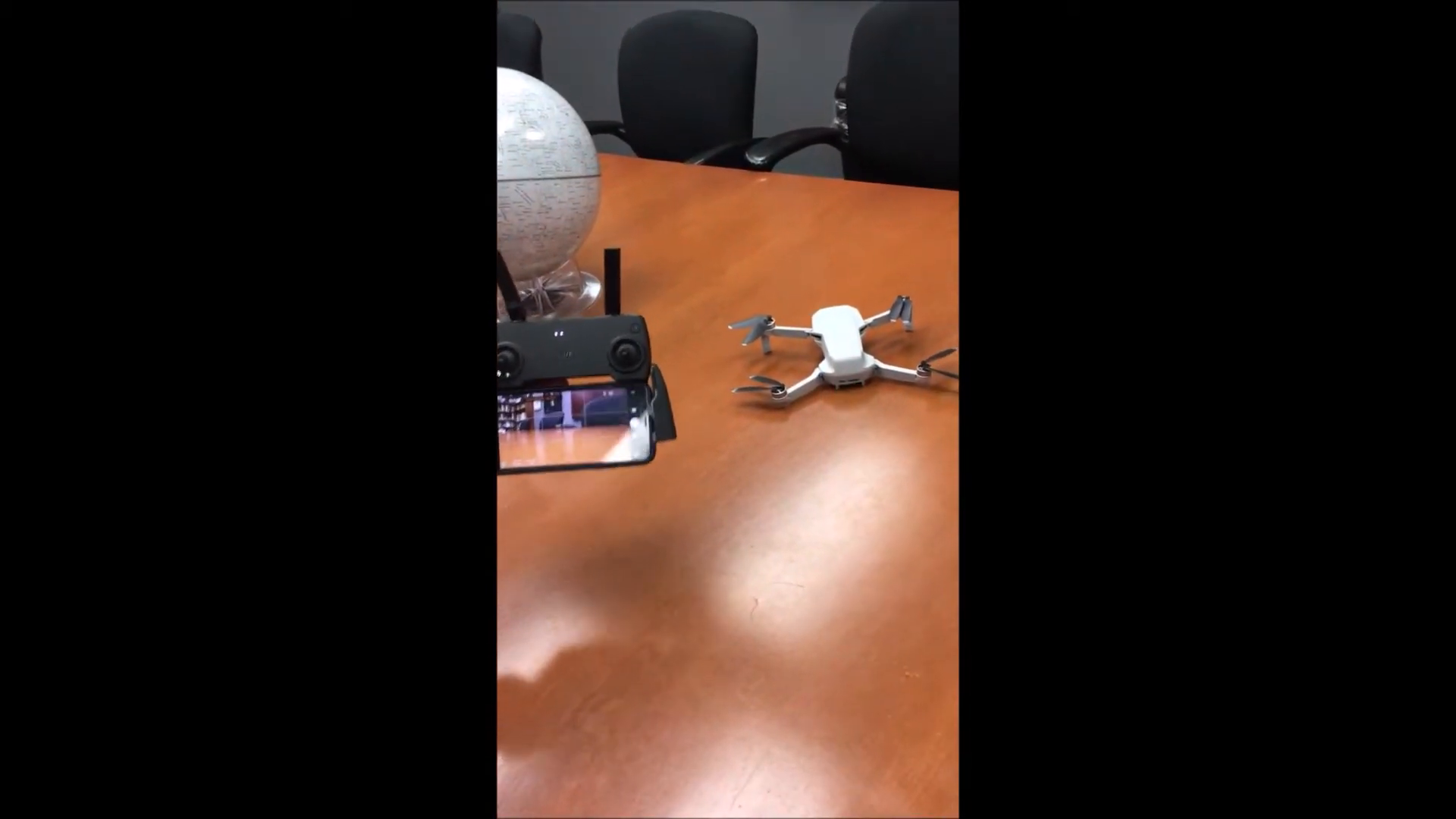
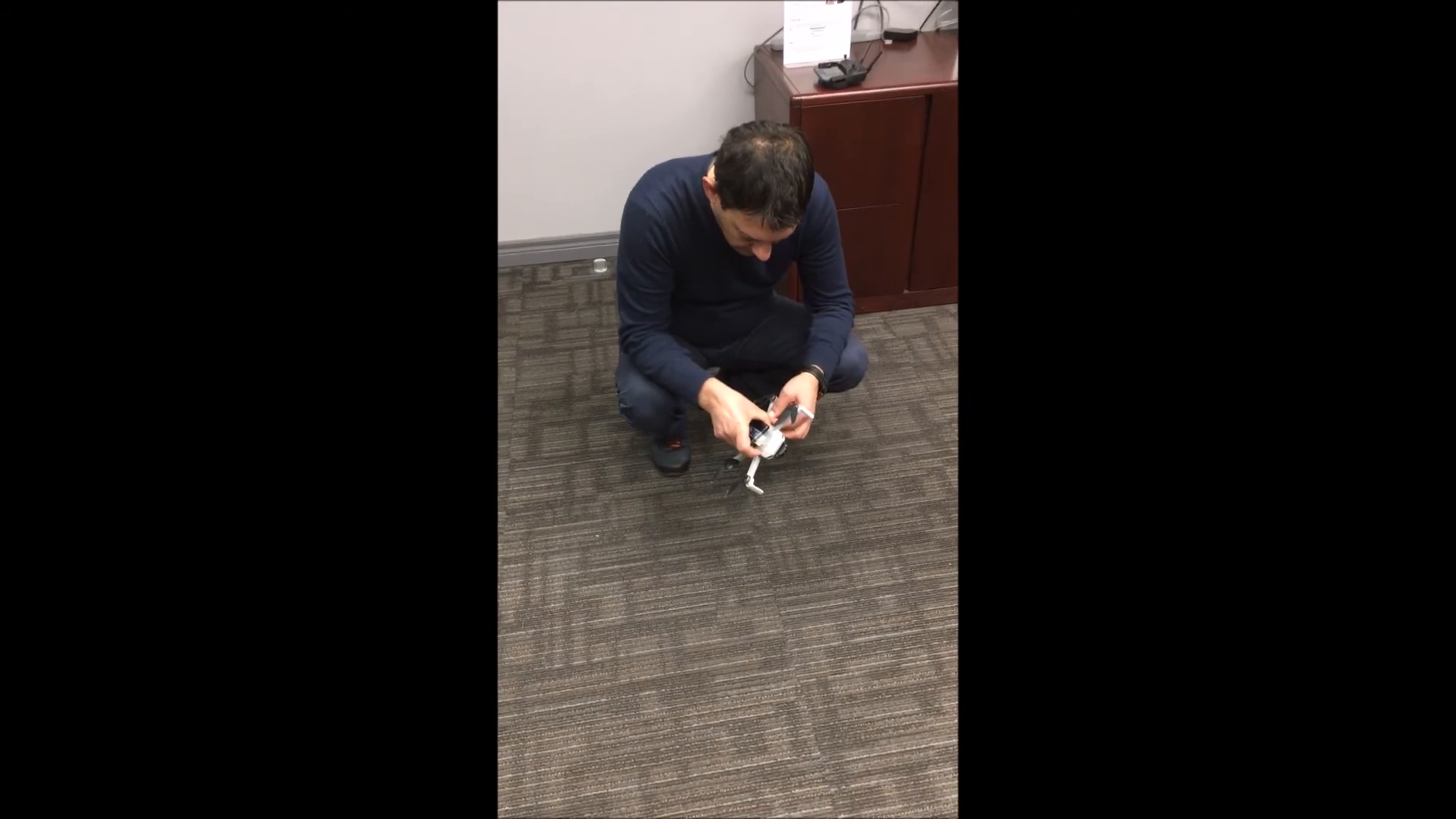
To appreciate how drones can be integrated into geological work, it's essential to understand the technology behind them. In this section, we will discuss the specifications and capabilities of modern drones, particularly focusing on the DJI Mini, a popular choice among geologists.

Key Features of the DJI Mini 📊
The DJI Mini is a compact drone weighing just 249 grams, making it exempt from licensing requirements in many regions. Its features include:
- Flight Speed: Capable of flying at speeds of up to 40 km/h.
- Maximum Elevation: Can reach heights of up to 500 meters.
- Flight Time: Offers approximately 30 minutes of flight time per charge.
- Range: Can operate within a range of 1.5 to 2 kilometers.
The combination of these features makes the DJI Mini an ideal choice for geological surveys, providing flexibility and efficiency in data collection.
Applications of Drones in Geological Surveys 🔍
Drones have a wide array of applications in geology, enhancing traditional methods and introducing innovative approaches. Here are some notable uses:
Topographic Mapping 🗺️
One of the primary applications of drones is creating detailed topographic maps. By capturing aerial images and using photogrammetry software, geologists can generate accurate 3D models of terrain. This is particularly useful in:
- Identifying geological formations.
- Assessing land use and planning.
- Monitoring changes in the landscape over time.
Geophysical Surveys 📉
Drones can also be integrated with geophysical sensors, such as magnetometers, to conduct surveys. This enables geologists to:
- Measure variations in the Earth's magnetic field.
- Identify potential mineral deposits.
- Assess subsurface structures without invasive drilling.
By combining drone technology with geophysical tools, geologists can gather extensive data quickly and safely.
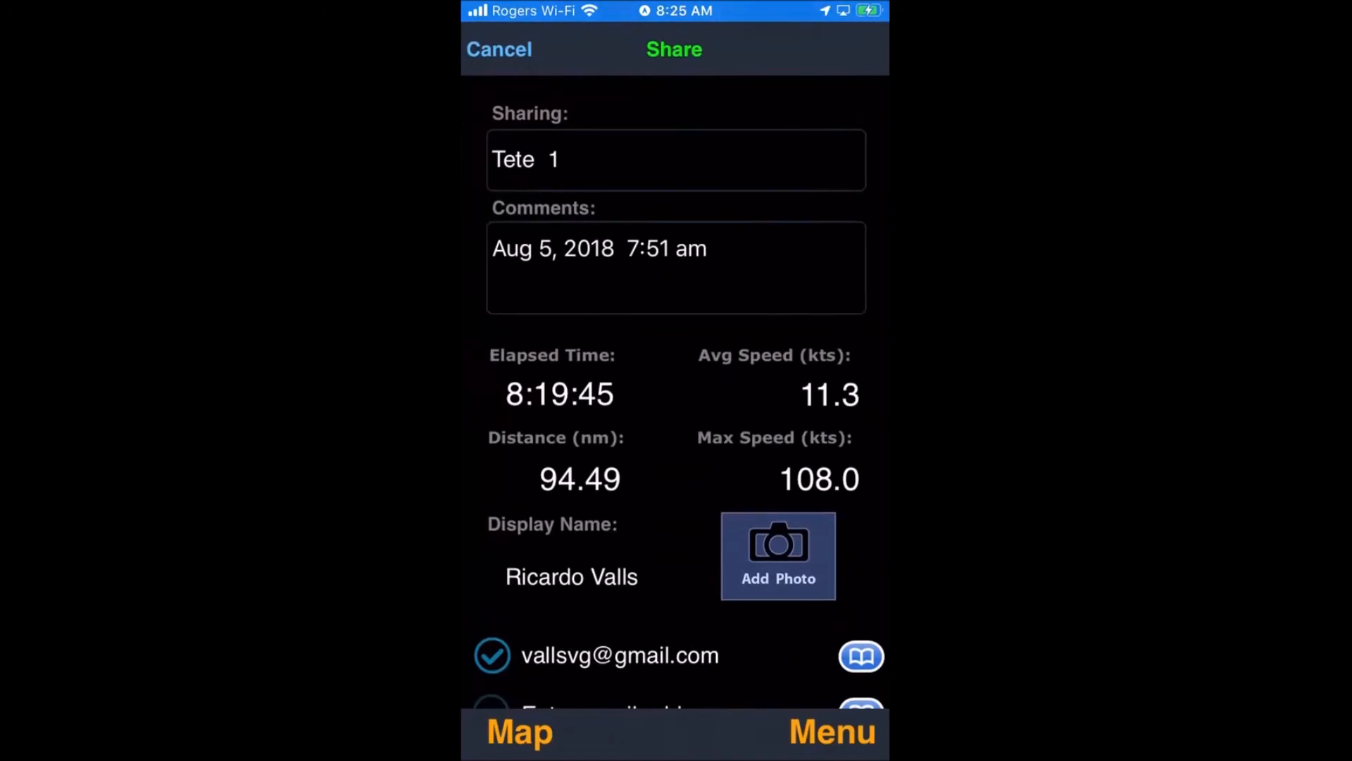
Combining Drones with Mobile Technology 📱
The integration of drones with mobile technology enhances their functionality. By using smartphones equipped with specific applications, geologists can collect and analyze data efficiently. This section will explore how mobile apps can be utilized alongside drones.
Using Mobile Apps for Geophysical Surveys 📊
Geologists can connect their smartphones to drones to gather geophysical data while flying. For instance, using an application like a Tesla meter allows for real-time monitoring of magnetic fields. This integration enables:
- Simultaneous data collection from multiple sources.
- Immediate analysis of results on-site.
- Efficient data management through exportable formats, such as CSV files.
This synergy between drones and mobile applications streamlines the survey process, making it easier to compile and analyze data.
Data Analysis and Visualization 📊
After collecting data, the next step involves analysis and visualization. Drones can capture thousands of data points during a flight, which can be processed to create comprehensive visual representations. This section discusses how geologists can analyze drone data effectively.
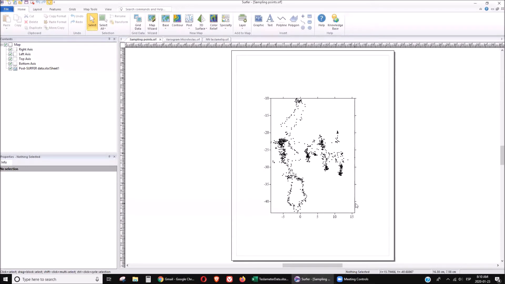
Creating Maps and Models 🗺️
Using software like Surfer, geologists can transform raw data from drones into informative maps and models. This process involves:
- Importing data into mapping software.
- Applying interpolation methods to create smooth surfaces.
- Exporting visualizations for reports or presentations.
These visual representations are critical for understanding geological features and informing decision-making.
Challenges and Considerations ⚠️
While drones offer remarkable advantages, there are challenges to consider. Geologists must navigate regulatory requirements, technical limitations, and environmental factors that can affect drone performance. This section outlines some of these challenges.
Regulatory Compliance 📜
In many regions, drone operations are subject to regulations that mandate licensing, safety protocols, and airspace restrictions. Geologists must ensure compliance with local laws to operate drones legally and safely.
Technical Limitations ⚙️
Despite their capabilities, drones have limitations, such as:
- Battery life constraints, which can limit the duration of surveys.
- Weather conditions that may hinder flight safety.
- Signal interference in remote areas that could affect data transmission.
Addressing these challenges is crucial for successful drone operations in geological exploration.
Conclusion: The Future of Drones in Geology 🌟
As technology continues to evolve, the role of drones in geological exploration is expected to expand. By combining advanced drone capabilities with mobile technology, geologists can enhance data collection and analysis, ultimately leading to more informed decisions in the field.
For more insights on the intersection of geology and technology, consider checking out Golden Droplets - YouTube, a platform that bridges the gap between academia and industry for aspiring and seasoned geologists alike.
FAQs 🤔
What types of drones are best for geological surveys?
The DJI Mini and similar models are popular due to their lightweight design, affordability, and advanced features suitable for geological applications.
How do drones improve data collection in geology?
Drones can access hard-to-reach areas, capture high-resolution images, and gather geophysical data quickly and efficiently, enhancing the overall data collection process.
Are there any regulations regarding drone use in geology?
Yes, regulations vary by region, and operators must comply with local laws regarding licensing, safety protocols, and airspace restrictions.
Can drones be used for other applications besides geology?
Absolutely! Drones are utilized in various fields, including agriculture, environmental monitoring, construction, and disaster management.
How can I learn more about using drones in geological surveys?
Consider joining professional organizations, attending workshops, or exploring online resources to gain knowledge about drone technology and its applications in geology. You can also check out ORCID for research publications and resources.
P. Geo. Ricardo A Valls, M. Sc.
Valls Geoconsultant
ORCID ID- https://orcid.org/0000-0002-5421-0914
Scopus Author ID: 7003369619/35335510700
ResearcherID: S-6604-2018
If you like this content, please "buy me a coffee" https://www.buymeacoffee.com/goldendroplets
#planetearth #geology #mining #exploration #education #earthscience #geologia #earthscienceteacher #cienciasnaturales #cienciasgeologicas #geochemistry #geochemistrybooks #geoquimica #trainingcourses #teachingonline #vallsgeoconsultant #vallsvg #technotectonics #goldendroplets #geovoices
Made with VideoToBlog

No comments:
Post a Comment